1970s Maps of Logan County, Kansas
Explore 20 historic maps of Logan County from the 1970s. These maps offer a rare glimpse into what life looked like during the 1970s — showing old roads, neighborhoods, homes, and landmarks that have changed or disappeared over time.
Whether you're researching your family's past, planning a metal detecting trip, or studying how Logan County's landscape evolved across the 1970s, these high-resolution maps are a powerful tool for exploring the history of this region.
- Focus on a specific era: All maps on this page are from the 1970s, giving you a focused view of this time period.
- See what’s changed: Compare century-old streets, trails, and buildings to today's modern landscape using overlays and satellite layers.
- Research with precision: Use these maps for genealogy, historical research, land use analysis, or educational projects.
- View, download, or print: Maps are fully viewable online in high resolution, and can be downloaded or printed for your own records.
Start exploring Logan County's history through authentic maps from the 1970s. This is your window into the past.
Logan County, KS maps
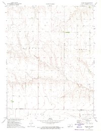
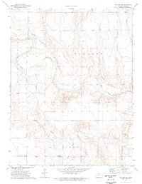
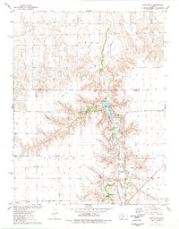
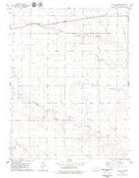
(20)- 1972 Map of Russell Springs, 1974 Print
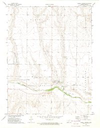 1972 Russell Springs1974 Print · USGSRussell Springs sat at a historic Western crossroads in the early 1970s, where frontier trails met the river valley. Genealogists and historians can trace the Butterfield Overland Trail, the Russell Springs Cem, and remnants of an Old Railroad Grade.
 - 1972 Map of Monument, 1974 Print
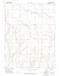
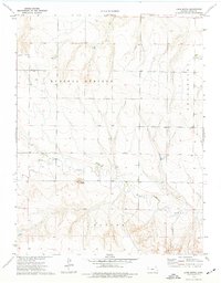
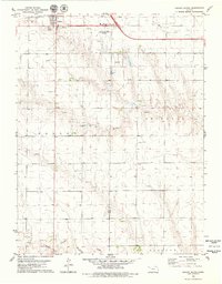
 1972 Monument1974 Print · USGSMonument and the surrounding Logan County plains are captured in the early 1970s just as the rural landscape maintained its traditional rail-and-creek orientation. Local historians can trace the Union Pacific corridor, the town of Monument, and the nearby Monument Cem.
 - 1972 Map of Winona, 1974 Print
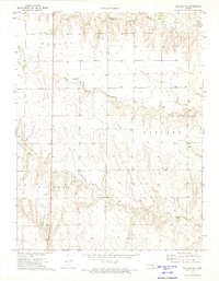
 1972 Winona1974 Print · USGSLogan County, Kansas, was a landscape of high-plains agriculture and critical rail corridors in the early seventies. Researchers can trace the path of the Union Pacific through Winona and Page City or locate the Winona Cem and local airstrips.
 - 1972 Map of Winona NE, 1974 Print
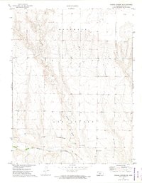
 1972 Winona NE1974 Print · USGSWestern Kansas ranching and energy lands are captured here in the early 1970s, where the Saline River begins its eastward journey. Genealogists and local historians can locate the Township Cem and trace the paths of the North Fork Saline River and South Fork Saline River.
 - 1972 Map of Winona NW, 1974 Print
 1972 Winona NW1974 Print · USGSThe High Plains of Western Kansas are captured here in the early seventies, showing the rural landscape along the Thomas Co border. Researchers can trace land divisions in Summers and locate water sources like the South Fork Saline River and various local Wells.
 - 1972 Map of Elkader NW, 1974 Print
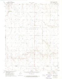
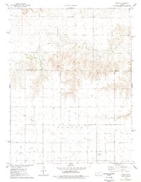
 1972 Elkader NW1974 Print · USGSLogan County, Kansas, is captured in the early 1970s as a landscape of high plains drainage and quiet industry. Researchers can find isolated landmarks like a solitary Grave, working Quarries, and the prominent Logan Monument rising above the plains.
 - 1972 Map of Elkader NE, 1974 Print
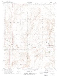
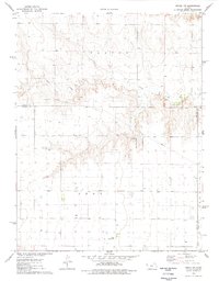
 1972 Elkader NE1974 Print · USGSWestern Kansas ranching country and the Logan-Gove county line appear here in the early 1970s. Trace the drainage of Hackberry Creek and locate local landmarks across the prairie highlands of Elkader and Gaeland O.
 - 1972 Map of Russell Springs NE, 1974 Print
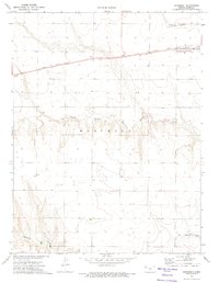
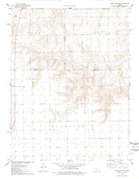
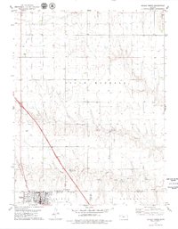
 1972 Russell Springs NE1974 Print · USGSWestern Kansas at the start of the 1970s reveals a landscape defined by historic transit and the Smoky Hill River. Trace the Butterfield Overland Trail and an Old Railroad Grade across the plains.
 - 1974 Map of Elkader SW, 1977 Print
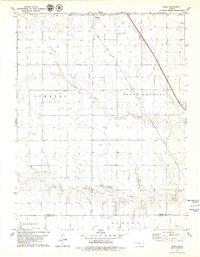
 1974 Elkader SW1977 Print · USGSThe High Plains of Logan County come into focus in the mid-1970s, revealing a landscape defined by historic transit and unique geology. Trace the Butterfield Trail, an Old Railroad Grade, and the landmark Little Pyramids.
 - 1974 Map of Elkader, 1977 Print
 1974 Elkader1977 Print · USGSWestern Kansas at the mid-seventies reveals a landscape shaped by the Smoky Hill River and the legacies of frontier travel. Trace the Butterfield Trail near the Chalk Pyramids and the historic settlement of Elkader.2 unique versions available
 - 1974 Map of Lone Butte, 1977 Print
 1974 Lone Butte1977 Print · USGSLogan County, Kansas, is captured in the mid-1970s as a landscape of rural townships and winding creek beds. Genealogists and historians can locate markers of local industry and transit, including a Quarry, several creek Ford crossings, and the namesake Lone Butte.
 - 1974 Map of Russell Springs SE, 1977 Print
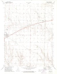
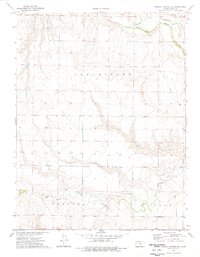 1974 Russell Springs SE1977 Print · USGSLogan County in the mid-1970s reveals a landscape where historic pioneer routes meet modern townships. Historians can trace the Butterfield Overland Location Trail near the Smoky Hill River or locate an Old Railroad Grade.
 - 1976 Map of Lake Scott, 1978 Print
 1976 Lake Scott1978 Print · USGSWestern Kansas canyon country comes to life in the mid-seventies, showing the deep draws and springs that provided rare refuge on the plains. Genealogists and historians can locate the El Cuartelejo Ruins, White Womans Grave, and the site of an Old Railroad Grade.
 - 1976 Map of Pence, 1978 Print
 1976 Pence1978 Print · USGSScott County and Logan County were largely defined by rural townships and agricultural industry in the mid-1970s. Genealogists can locate family landmarks like Pence Cem and Scott Ch near the historic settlement of Pence.
 - 1976 Map of Pence NW, 1978 Print
 1976 Pence NW1978 Print · USGSWestern Kansas at the height of the 1970s shows a landscape of agricultural utility and aviation transit at the county lines. Trace local infrastructure through private aviation sites like Kough Landing Strip and the winding course of Chalk Creek.
 - 1976 Map of Lake Scott NE, 1978 Print
 1976 Lake Scott NE1978 Print · USGSWestern Kansas at the mid-seventies reveals a landscape of high-plains agriculture and emerging energy sites. Genealogists and local historians can trace family land via field lines near Ryan, visit the Keystone Cem, and follow the seasonal flow of Hell Creek.
 - 1979 Map of Oakley SW
 1979 Oakley SW1979 Print · USGSLogan County, Kansas, is shown in the late 1970s as a landscape of energy production and rail transport. Researchers can trace the path of the Union Pacific railroad and locate an active Oil Field or several Gravel Pits along the creek branches.
 - 1979 Map of Oakley South
 1979 Oakley South1979 Print · USGSOakley and the surrounding prairie of Logan and Gove Counties are documented here during the late 1970s. Local researchers can trace the development of the Union Pacific rail corridor and find family landmarks like the Country Chapel and Zion Cem.
 - 1979 Map of Oakley North
 1979 Oakley North1979 Print · USGSThe High Plains of West Kansas meet at the confluence of the Saline River forks in the late seventies. Researchers can trace family sites at Oakley Cem or St Josephs Cem, and locate early civic landmarks like the Townhall and Fairground.
 - 1979 Map of Spica
 1979 Spica1979 Print · USGSThe High Plains of Thomas County come alive in the late 1970s, showing the convergence of the Saline River forks. Researchers can trace the path of the Union Pacific railroad near Spica and locate regional landmarks like the Oil Field and Feedlot.2 unique versions available
End of results
Showing maps 1-20 of 20
Top cities of Logan County
- Oakley historical maps
- Winona historical maps
- Monument historical maps
- McAllaster historical maps
- Russell Springs historical maps
- Elkader historical maps
Frequently asked questions
- What are the different types of historical maps available for Logan County?
- What is the oldest map of Logan County?
- Where can I purchase historical maps of Logan County for my home or office?
- Where can I download high-res historical maps of Logan County?
- Are there historical topographic maps available for Logan County?
- Is there historical aerial imagery available for Logan County?
- Where are historical maps of Logan County sourced from?