1910s Maps of Nebraska
Explore 4 historic maps of Nebraska from the 1910s. These maps offer a rare glimpse into what life looked like during the 1910s — showing old roads, neighborhoods, homes, and landmarks that have changed or disappeared over time.
Whether you're researching your family's past, planning a metal detecting trip, or studying how Nebraska's landscape evolved across the 1910s, these high-resolution maps are a powerful tool for exploring the history of this region.
- Focus on a specific era: All maps on this page are from the 1910s, giving you a focused view of this time period.
- See what’s changed: Compare century-old streets, trails, and buildings to today's modern landscape using overlays and satellite layers.
- Research with precision: Use these maps for genealogy, historical research, land use analysis, or educational projects.
- View, download, or print: Maps are fully viewable online in high resolution, and can be downloaded or printed for your own records.
Start exploring Nebraska's history through authentic maps from the 1910s. This is your window into the past.
Nebraska maps
(4)- 1915 Map of Falls City
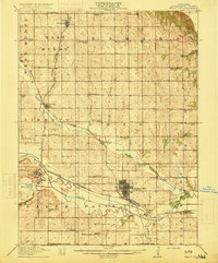 1915 Falls City1915 Print · USGSRichardson County was a bustling corridor of rail lines and rural school districts during the early twentieth century. Genealogists can trace family footprints across dozens of local landmarks like Williamsville School, Straussville, and the Stone Quarry along the river.3 unique versions available
 - 1915 Map of Nemaha
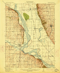 1915 Nemaha1915 Print · USGSThe Missouri River borderlands between Nebraska and Missouri are captured here in the years before major flood control altered the channel. Genealogists can trace family roots through dozens of rural landmarks, including Mt Vernon Cemetery, Antioch Church, and the river landing at St Deroin.2 unique versions available
 - 1915 Map of Howe
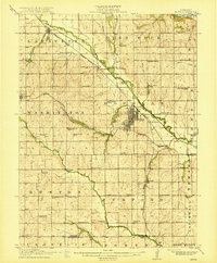 1915 Howe1915 Print · USGSSoutheast Nebraska’s agricultural heartland is documented here just before the First World War, centered on the growing rail hub of Auburn. Researchers can trace early rural life through dozens of named country schoolhouses like Grand Prairie School and local shipping points such as Borton Siding.2 unique versions available
 - 1916 Map of Humboldt
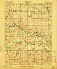 1916 Humboldt1916 Print · USGSRichardson County was a landscape of river-valley farming and emerging drainage projects during the mid-1910s. Researchers can trace the development of rural education and transport through dozens of local landmarks like Windy Lonesome School, Miles Ranch, and the Missouri Pacific line.3 unique versions available
End of results
Showing maps 1-4 of 4
Top cities of Nebraska
- Omaha historical maps
- Lincoln historical maps
- Bellevue historical maps
- Grand Island historical maps
- Kearney historical maps
- Fremont historical maps
See more
Top counties of Nebraska
- Douglas County historical maps
- Lancaster County historical maps
- Sarpy County historical maps
- Hall County historical maps
- Buffalo County historical maps
- Dodge County historical maps
See more
Frequently asked questions
- What are the different types of historical maps available for Nebraska?
- What is the oldest map of Nebraska?
- Where can I purchase historical maps of Nebraska for my home or office?
- Where can I download high-res historical maps of Nebraska?
- Are there historical topographic maps available for Nebraska?
- Is there historical aerial imagery available for Nebraska?
- Where are historical maps of Nebraska sourced from?