1950s Maps of Chaves County, New Mexico
Explore 36 historic maps of Chaves County from the 1950s. These maps offer a rare glimpse into what life looked like during the 1950s — showing old roads, neighborhoods, homes, and landmarks that have changed or disappeared over time.
Whether you're researching your family's past, planning a metal detecting trip, or studying how Chaves County's landscape evolved across the 1950s, these high-resolution maps are a powerful tool for exploring the history of this region.
- Focus on a specific era: All maps on this page are from the 1950s, giving you a focused view of this time period.
- See what’s changed: Compare century-old streets, trails, and buildings to today's modern landscape using overlays and satellite layers.
- Research with precision: Use these maps for genealogy, historical research, land use analysis, or educational projects.
- View, download, or print: Maps are fully viewable online in high resolution, and can be downloaded or printed for your own records.
Start exploring Chaves County's history through authentic maps from the 1950s. This is your window into the past.
Chaves County, NM maps
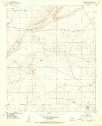
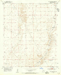
(36)- 1950 Map of Dexter West
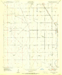 1950 Dexter West1950 Print · USGSChaves County's agricultural and ranching heartland is captured here at mid-century, just as the regional economy was being shaped by irrigation and aviation. Genealogists and historians can trace family holdings like Lowe Ranch or locate industrial sites like Bogies Cotton Gin and the Twin Wells Stock Pens.4 unique versions available
 - 1950 Map of Corn Ranch
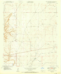
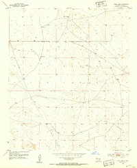
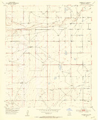
 1950 Corn Ranch1950 Print · USGSChaves County ranching lands are captured here at mid-century, showing the critical infrastructure of water and travel in the high desert. Researchers can trace remote homesteads and wells like Corn Ranch, Rosenberg Well, and the path of the Roswell-Pine Lodge Road.
 - 1950 Map of Comanche Spring
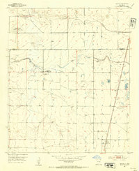
 1950 Comanche Spring1950 Print · USGSChaves County ranching lands and the western edge of the Pecos River valley are captured in the early fifties. Researchers can trace the essential water network of the era, from the namesake Comanche Spring to dozens of scattered Windmills.3 unique versions available
 - 1950 Map of Bottomless Lakes
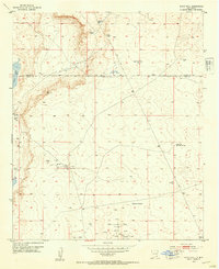
 1950 Bottomless Lakes1950 Print · USGSThe high plains of Chaves County meet the Pecos River valley at mid-century, where unique sinkhole geology created a legendary desert oasis. Researchers can trace historic property boundaries like Atkinson Ranch and find early recreational landmarks including Lea Lake and the Fin and Feather Club.4 unique versions available
 - 1950 Map of South Spring
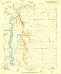
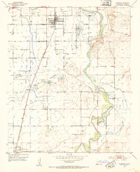
 1950 South Spring1950 Print · USGSThe Pecos River valley in the early 1950s shows a landscape transformed by the Hagerman Canal and the railroad. Genealogists can trace the rural communities of Orchard Park and Oasis, including the local Oasis Sch.
 - 1950 Map of Bitter Lake
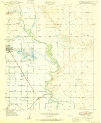
 1950 Bitter Lake1950 Print · USGSMid-century Chaves County comes to life in this survey of the Pecos River valley and its surrounding high plains. Researchers can locate the St Marys Cem, trace the Atchison Topeka and Santa Fe rail line, or explore the early grounds of the Roswell Country Club.
 - 1950 Map of Dexter East
 1950 Dexter East1950 Print · USGSThe Pecos River valley comes alive in this mid-century survey of Chaves County agriculture and irrigation. Genealogists and local historians can trace the rail-side growth of Dexter and Greenfield or locate the Dexter Federal Fish Hatchery and Calumet Ranch.3 unique versions available
 - 1951 Map of Ninemile Well, 1953 Print
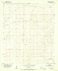
 1951 Ninemile Well1953 Print · USGSChaves County ranching life in the early fifties was centered on remote outposts and vital water sources scattered across the desert. Genealogy researchers can locate family sites like Greer Ranch or trace cattle-country landmarks like Ninemile Well and Rattlesnake Windmill.3 unique versions available
 - 1951 Map of King Camp, 1953 Print
 1951 King Camp1953 Print · USGSRanching and early infrastructure define this Chaves County landscape during the early fifties. Researchers can trace the layout of the Anchor D Ranch, the central King Camp, and the path of a significant Pipe Line through the territory.3 unique versions available
 - 1951 Map of Diamond Mound, 1953 Print
 1951 Diamond Mound1953 Print · USGSEddy and Chaves Counties are captured here in the early fifties, showing a landscape of high-desert ranching and alkaline basins. Researchers can locate remote outposts like Merritt Ranch and trace the drainage patterns of Derrick Draw and Flat Lake.
 - 1951 Map of Hagerman, 1953 Print
 1951 Hagerman1953 Print · USGSAgricultural life in Chaves County flourished in the early fifties as irrigation and rail lines connected the Pecos River valley. Genealogists and local historians can trace family roots through the streets of Hagerman and Lake Arthur, or locate landmarks like Mossman and Hagerman Cemetery.2 unique versions available
 - 1952 Map of Connor Well, 1953 Print
 1952 Connor Well1953 Print · USGSChaves County ranching and early petroleum interests come into focus in this mid-century survey of the New Mexico plains. Researchers can locate specific water and energy sites including Connor Well, Horse Camp Wells, and several instances of Oil Well (Aban'd).2 unique versions available
 - 1952 Map of Bar C Bar Ranch, 1953 Print
 1952 Bar C Bar Ranch1953 Print · USGSChaves County ranching lands are captured here in the early fifties, showing how water and livestock shaped the high plains. Researchers can trace historic ranch boundaries and water sources like Bar C Bar Ranch, Redtower Windmill, and Long Arroyo.2 unique versions available
 - 1952 Map of Hagerman SW, 1954 Print
 1952 Hagerman SW1954 Print · USGSChaves County ranching and irrigation come to life in the early 1950s as the Rio Felix cuts through the high desert. Genealogists and local historians can trace legacy sites like Hurst Ranch, the Hagerman Canal, and Lake Arthur Cemetery.2 unique versions available
 - 1953 Map of Espuela, 1954 Print
 1953 Espuela1954 Print · USGSSoutheast New Mexico in the early fifties shows a landscape of artesian wells and shifting industry along the railroad. Researchers can locate the Cottonwood School, the Cottonwood Community Church, and the now-abandoned Walker Air Base Emergency Landing Field.2 unique versions available
 - 1953 Map of Basin Well, 1954 Print
 1953 Basin Well1954 Print · USGSSoutheast New Mexico ranching and oil exploration are documented here during the mid-fifties along the Chaves and Eddy County line. Researchers can locate remote desert water sources like Double Wells Tank and industrial markers ranging from a solitary Landing Strip to the High Lonesome Windmill.2 unique versions available
 - 1954 Map of Carlsbad, 1963 Print
 1954 Carlsbad1963 Print · USGSSoutheastern New Mexico's desert peaks and river valleys appear in this mid-century study of the borderlands. Researchers can locate vanished sites like Sacramento City, trace the Pecos River reservoirs, and explore Carlsbad Caverns.3 unique versions available
 - 1954 Map of Hobbs, 1963 Print
 1954 Hobbs1963 Print · USGSThe High Plains and Permian Basin transition is captured here at the height of the mid-century energy boom. Genealogists and industrial historians can trace the foundations of Humble City, locate the Potash Mine and Plant, and follow the Texas-New Mexico RR.2 unique versions available
 - 1954 Map of Fort Sumner, 1964 Print
 1954 Fort Sumner1964 Print · USGSEast-central New Mexico's ranching and rail heartland is captured here in the mid-1950s, centered on the strategic junctions of the high plains. Researchers can trace the development of early highway networks and rail towns like Vaughn, Fort Sumner, and the copper operations at Guadalupe Mine.3 unique versions available
 - 1954 Map of Clovis, 1966 Print
 1954 Clovis1966 Print · USGSThe High Plains of the Texas-New Mexico borderland come alive in this mid-century survey as the region's agricultural and rail networks reached their peak. Trace family roots and local history through features like Cannon AFB, the massive Sand Hills, and busy rail towns such as Friona and Littlefield.4 unique versions available
 - 1954 Map of Brownfield, 1975 Print
 1954 Brownfield1975 Print · USGSThe High Plains of the Texas-New Mexico border are captured here in the mid-twentieth century, as ranching and oil extraction shaped the Llano Estacado. Genealogists and historians can trace small rural centers like Lums Chapel, Hillburn City, and the Friendship Sch amid a landscape of windmills.2 unique versions available
 - 1955 Map of Artesia NE, 1956 Print
 1955 Artesia NE1956 Print · USGSThe high plains of Eddy and Chaves County come alive in the mid-1950s as the river valley meets early oil exploration. Trace the rail-and-river network from Lake Arthur down the Pecos River or locate the remote Oil Well and Oil Tank in the eastern flats.3 unique versions available
 - 1955 Map of Hope NW, 1956 Print
 1955 Hope NW1956 Print · USGSEddy and Chaves Counties in the mid-fifties show a landscape shaped by ranching and seasonal water. Genealogists and historians can trace isolated homesteads like the Kincaid Ranch and Runyan Place among the drainage of North Cottonwood Creek.
 - 1955 Map of Hackberry Ranch, 1956 Print
 1955 Hackberry Ranch1956 Print · USGSMid-century Chaves County ranching life is preserved on this sheet, showing the vast grazing lands before further modern development. Genealogists and historians can trace the family-held Hackberry Ranch, Smith Ranch, and the isolated Auxiliary Landing Field No 3.
 - 1955 Map of Kincaid Ranch, 1956 Print
 1955 Kincaid Ranch1956 Print · USGSChaves County ranching life is preserved here during the mid-1950s, showing a landscape defined by isolated homesteads and vital water sources. Researchers can locate family outposts like Price Ranch and Kincaid Ranch or trace the course of Rio Felix.
Showing maps 1-25 of 36
Top cities of Chaves County
Frequently asked questions
- What are the different types of historical maps available for Chaves County?
- What is the oldest map of Chaves County?
- Where can I purchase historical maps of Chaves County for my home or office?
- Where can I download high-res historical maps of Chaves County?
- Are there historical topographic maps available for Chaves County?
- Is there historical aerial imagery available for Chaves County?
- Where are historical maps of Chaves County sourced from?