Old Maps of Wayne County, Tennessee for Metal Detecting
Plan your next treasure hunt with 133 historic maps of Wayne County. Find old homesites, ghost towns, trails, and gathering spots that may be lost to time — perfect for identifying promising metal detecting locations.
- Locate forgotten sites: Uncover places like long-lost settlements, abandoned rail lines, or gathering spots.
- Plan better hunts: Use map overlays combined with LiDAR or satellite views to narrow in on historically rich areas.
- Made for detectorists: Thousands of hobbyists use these maps to discover relics, coins, and hidden history.
Use these historic maps to boost your research and find new opportunities beneath the surface of Wayne County.
Wayne County, TN maps
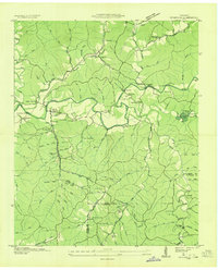
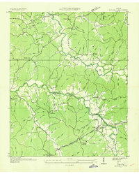
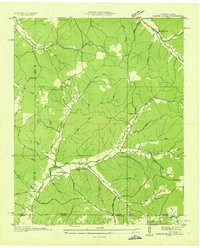
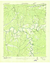
(133)- 1905 Map of Waynesboro
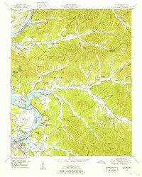
 1905 Waynesboro1905 Print · USGSWayne County and the Tennessee-Alabama borderlands are captured here at the start of the century, showing a network of river landings and old stage stands. Researchers can trace the Nathez Trace and locate historic community hubs like Martins Mills, Whittens Stand, and Clifton.2 unique versions available
 - 1936 Map of Riverside
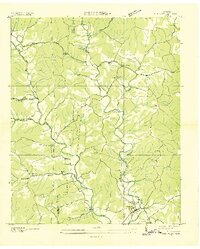
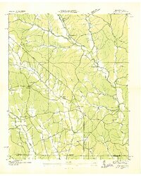
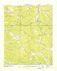
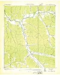
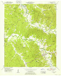
 1936 Riverside1936 Print · USGSThe Buffalo River valley in the mid-1930s shows a landscape of small settlements and river crossings like Metal Ford. Trace family history at CCC Camp No 1472 or local landmarks like Ruppertown and Riverside Sch.
 - 1936 Map of Westpoint
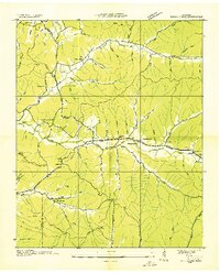
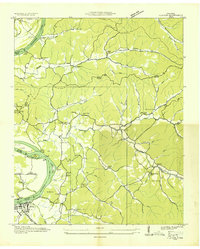
 1936 Westpoint1936 Print · USGSThe Lawrence County backcountry comes into focus during the mid-1930s, showing a landscape of small creek-side settlements and rural schools. Genealogists can trace family roots through landmarks like Gallaher Cem, Lopps Chapel, and Springer Sch.
 - 1936 Map of Collinwood
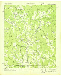
 1936 Collinwood1936 Print · USGSCollinwood and the surrounding Wayne County hill country appear here during the mid-1930s as a landscape of rural schools and active rail lines. Genealogists and researchers can locate family-named sites like McGlamerys Stand and McCall Sch or trace the early paths of State Highway 13.
 - 1936 Map of Eagle Creek
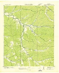
 1936 Eagle Creek1936 Print · USGSThe Tennessee borderlands of Wayne and Hardin Counties appear in the mid-1930s as a landscape of rural schoolhouses and family hollows. Researchers can trace the community life of the era through sites like Shady Grove Sch, Bethany Ch, and Old Mill Spring.
 - 1936 Map of Olivehill
 1936 Olivehill1936 Print · USGSHardin County and Wayne County meet along the ridges of the Tennessee Valley during the mid-1930s. Genealogists can trace family footprints through rural landmarks like Piney Grove, Bethlehem, and schools such as Havana Sch and Hannah Sch.
 - 1936 Map of Bath Springs
 1936 Bath Springs1936 Print · USGSThe Tennessee River valley in the mid-1930s was a landscape defined by its river landings and rural crossroads. You can trace dozens of historic river access points like Furnace Landing and Jeter Landing alongside local landmarks like Bath Springs Ch.
 - 1936 Map of Light
 1936 Light1936 Print · USGSThe borderlands of Tennessee and Alabama come alive in this mid-1930s survey of rural Wayne County. Researchers can trace the heritage of Pleasant Valley through its many landmarks like Friendship Sch, Oak Grove Ch, and Sweaney Sch.
 - 1936 Map of Leatherwood
 1936 Leatherwood1936 Print · USGSThe Buffalo and Green River valleys of Wayne County were still a world of fords and ferries in the mid-1930s. Researchers can locate family landmarks like Holt Cem, the community at Flat Woods, and rural schools including Phillips Sch and Pope Sch.
 - 1936 Map of Negro Hollow
 1936 Negro Hollow1936 Print · USGSWayne County was characterized by its network of hollows and creek-side settlements during the mid-1930s. Genealogists can trace family landmarks and schools across this rural landscape, from Copeland Cem and Simmons to the Forty-eight Creek Sch.
 - 1936 Map of Clifton
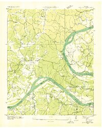
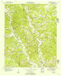
 1936 Clifton1936 Print · USGSThe Tennessee River corridor around Clifton was a network of active landings and rural ridge communities during the mid-1930s. Researchers can trace ancestral locations through several family-named cemeteries like Tucker Cem and Prater Cem, or map old river crossings such as Clifton Ferry.
 - 1936 Map of Cypress Inn
 1936 Cypress Inn1936 Print · USGSThe Tennessee-Alabama borderlands come alive in the mid-1930s, showcasing a landscape defined by the historic Natchez Trace. Genealogists can locate family landmarks like Balentine Cem, Dodds Mill, and the many rural schools of Wayne County.
 - 1936 Map of Three Churches
 1936 Three Churches1936 Print · USGSWayne County during the mid-1930s was a landscape of remote creek-side communities and family homesteads. Genealogists can trace local heritage through landmarks like Three Churches, the Mill Dam at Victory, and schools like Memorial Sch.
 - 1936 Map of Ransom Stand
 1936 Ransom Stand1936 Print · USGSThe Tennessee-Alabama state line in the mid-1930s reveals a rural landscape defined by family-named hollows and creek-side settlements. Genealogists can trace local roots through the Centenary Cem, Stout Cem, and neighborhood schoolhouses like the Dodd Sch.
 - 1936 Map of St. Joseph
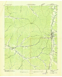
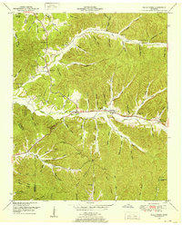
 1936 St. Joseph1936 Print · USGSThe Tennessee-Alabama borderlands come alive in the mid-1930s, showing a transition from rail-dependent industry to early highway travel. Researchers can trace the Louisville and Nashville Company line through Iron City and find rural landmarks like Wolf Creek Mill and Mt Lebo Sch.
 - 1936 Map of Waynesboro
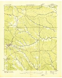
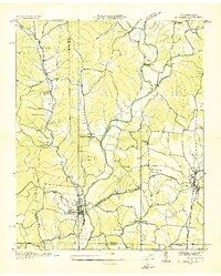
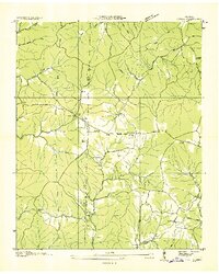
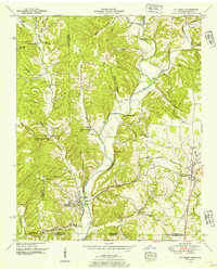
 1936 Waynesboro1936 Print · USGSWaynesboro and the surrounding Wayne County hills are captured here in the mid-thirties as rural electrification began to transform the region. Genealogists can locate family landmarks like Morris Cem and Shields Cem or early schools including Lone Cedar Sch.
 - 1936 Map of Martins Mills
 1936 Martins Mills1936 Print · USGSWayne County's rural landscape is captured here in the mid-1930s, showing a network of creeks and small settlements. Researchers can locate family landmarks like Mt Heber Cem, early schools such as Rayburn Sch, and the community of Lutts.
 - 1936 Map of Topsy
 1936 Topsy1936 Print · USGSWayne County was a network of river crossings and hollow-side farms in the mid-1930s before modern infrastructure altered the landscape. Researchers can trace ancestral roots at Topsy, locate rural hubs like Ashland, and find remote burial sites such as Zion Cem.
 - 1936 Map of Ovilla
 1936 Ovilla1936 Print · USGSThe border of Wayne and Lawrence Counties in the mid-1930s reveals a quiet landscape of rural schoolhouses and family cemeteries. Trace old property lines near Highland School, County Line Church, and the waters of the Little Buffalo River.
 - 1949 Map of Eagle Creek, 1952 Print
 1949 Eagle Creek1952 Print · USGSWayne and Hardin counties in the late 1940s reveal a deeply rural Tennessee landscape structured by winding creek bottoms and isolated ridges. Genealogists can trace family names through numerous remote burial sites like Montague Cem and Friendship Cem, or locate landmarks such as Evans Chapel and the Lookout Tower.3 unique versions available
 - 1949 Map of Bath Springs, 1952 Print
 1949 Bath Springs1952 Print · USGSThe Tennessee River corridor in the late 1940s shows a landscape of river landings and ridge-top settlements along the Decatur and Perry county lines. Genealogists can locate family-named landmarks like Lafferty Cemetery and Tuckers Store or trace the rural river economy at Yarbro Landing.3 unique versions available
 - 1949 Map of Clifton, 1952 Print
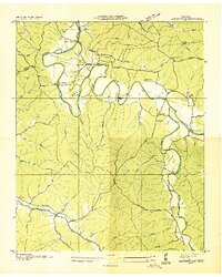
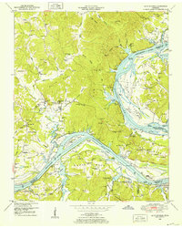
 1949 Clifton1952 Print · USGSThe riverfront town of Clifton and its surrounding ridges are captured in the late 1940s as the Tennessee River valley adapted to the impacts of Kentucky Lake. Genealogists can trace family landmarks and community nodes like Peters Landing, New Zion Ch, and the Lone Chestnut Cem.4 unique versions available
 - 1949 Map of Olivehill, 1952 Print
 1949 Olivehill1952 Print · USGSThe Tennessee and Wayne County border comes alive in the late 1940s, showing a landscape defined by its river crossings and hollows. Genealogists can locate family landmarks like Patterson Cem, Bolden Spring, and the rural community of Olivehill.3 unique versions available
 - 1950 Map of Westpoint, 1954 Print
 1950 Westpoint1954 Print · USGSThe Westpoint area of middle Tennessee is shown here during a period of industrial and rural transition. Local researchers can trace the routes of a Dismantled Railroad, find family landmarks like Sims Ridge Cem, and locate the sites of Silver Springs School and Lodi.2 unique versions available
 - 1950 Map of St. Joseph, 1954 Print
 1950 St. Joseph1954 Print · USGSThe Tennessee-Alabama borderlands come into focus in the early 1950s, showing the rural communities and rail lines that connected these cross-state ridges. Researchers can trace the Louisville and Nashville Railroad through Iron City or locate old burial sites like Shiloh Cem and Blair Cem.2 unique versions available
Showing maps 1-25 of 133
Top cities of Wayne County
Frequently asked questions
- What are the different types of historical maps available for Wayne County?
- What is the oldest map of Wayne County?
- Where can I purchase historical maps of Wayne County for my home or office?
- Where can I download high-res historical maps of Wayne County?
- Are there historical topographic maps available for Wayne County?
- Is there historical aerial imagery available for Wayne County?
- Where are historical maps of Wayne County sourced from?