1960s Maps of Beaver County, Utah
Explore 6 historic maps of Beaver County from the 1960s. These maps offer a rare glimpse into what life looked like during the 1960s — showing old roads, neighborhoods, homes, and landmarks that have changed or disappeared over time.
Whether you're researching your family's past, planning a metal detecting trip, or studying how Beaver County's landscape evolved across the 1960s, these high-resolution maps are a powerful tool for exploring the history of this region.
- Focus on a specific era: All maps on this page are from the 1960s, giving you a focused view of this time period.
- See what’s changed: Compare century-old streets, trails, and buildings to today's modern landscape using overlays and satellite layers.
- Research with precision: Use these maps for genealogy, historical research, land use analysis, or educational projects.
- View, download, or print: Maps are fully viewable online in high resolution, and can be downloaded or printed for your own records.
Start exploring Beaver County's history through authentic maps from the 1960s. This is your window into the past.
Beaver County, UT maps
(6)- 1960 Map of Lund
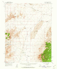
 1960 Lund1960 Print · USGSEastern Nevada and the Utah borderlands are mapped here during the mid-twentieth century, showing a landscape of high peaks and isolated ranching outposts. Researchers can locate remote mining sites like the Tungsten Queen Mine and early settlements including Lund and Shoshone.
 - 1960 Map of Frisco Peak, 1962 Print
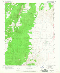
 1960 Frisco Peak1962 Print · USGSThe high desert of western Utah is captured here in the early sixties, showing the rugged intersection of the Beaver and Millard county lines. Researchers can trace historic industrial sites like the Two Rock Charcoal Kilns, Indian Queen Mine, and remote outposts such as Bagnell Corral.2 unique versions available
 - 1960 Map of Wah Wah Summit, 1962 Print
 1960 Wah Wah Summit1962 Print · USGSThe western Utah desert at the start of the 1960s shows a landscape defined by ranching and ecological research. Genealogists and historians can trace old landmarks like Kelleys Place and Range Headquarters or follow the Sand Pass Jeep Trail.2 unique versions available
 - 1960 Map of Beaver Lake Mts., 1962 Print
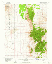
 1960 Beaver Lake Mts.1962 Print · USGSThe Millard and Beaver county line ran through a busy mining district in the early sixties. You can trace early industrial sites like the Galena Mine, locate the Charcoal Kilns, and find the School Bus Corral near the Frisco Mts.2 unique versions available
 - 1962 Map of Cove Fort, 1964 Print
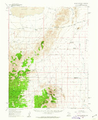
 1962 Cove Fort1964 Print · USGSCentral Utah in the early sixties reveals a high-desert landscape defined by historic waypoints and volcanic terrain. Genealogists and historians can trace routes through Cove Fort and Sulphurdale, or locate landmarks like Cinder Crater and Cedar Grove.
 - 1966 Map of Circleville, 1968 Print
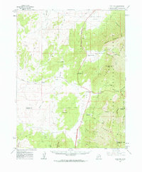
 1966 Circleville1968 Print · USGSThe Mormon village of Circleville is captured in the mid-sixties as it serves the surrounding high-desert ranching and farming operations. Researchers can trace irrigation networks like the Lost Creek Canal and find family-named landmarks such as Betenson Flat and Lums Creek.
End of results
Showing maps 1-6 of 6
Top cities of Beaver County
Frequently asked questions
- What are the different types of historical maps available for Beaver County?
- What is the oldest map of Beaver County?
- Where can I purchase historical maps of Beaver County for my home or office?
- Where can I download high-res historical maps of Beaver County?
- Are there historical topographic maps available for Beaver County?
- Is there historical aerial imagery available for Beaver County?
- Where are historical maps of Beaver County sourced from?