1920s Maps of Tooele County, Utah
Explore 2 historic maps of Tooele County from the 1920s. These maps offer a rare glimpse into what life looked like during the 1920s — showing old roads, neighborhoods, homes, and landmarks that have changed or disappeared over time.
Whether you're researching your family's past, planning a metal detecting trip, or studying how Tooele County's landscape evolved across the 1920s, these high-resolution maps are a powerful tool for exploring the history of this region.
- Focus on a specific era: All maps on this page are from the 1920s, giving you a focused view of this time period.
- See what’s changed: Compare century-old streets, trails, and buildings to today's modern landscape using overlays and satellite layers.
- Research with precision: Use these maps for genealogy, historical research, land use analysis, or educational projects.
- View, download, or print: Maps are fully viewable online in high resolution, and can be downloaded or printed for your own records.
Start exploring Tooele County's history through authentic maps from the 1920s. This is your window into the past.
Tooele County, UT maps
(2)- 1925 Map of Gold Hill, 1955 Print
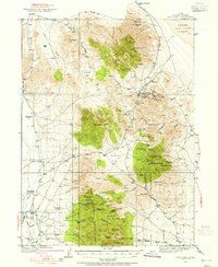 1925 Gold Hill1955 Print · USGSThe mining landscape of western Utah is preserved here during the mid-1920s, showing the high-desert settlements and remote mineral claims. Researchers can trace early mining operations at Gold Hill Mine or find historical family homesteads like Erickson Ranch and Sheridan Ranch.3 unique versions available
 - 1928 Map of Gold Hill
 1928 Gold Hill1928 Print · USGSThe Tooele County mining district comes into sharp focus during the late 1920s as industry pushed into the high desert. Genealogists and historians can trace the foundations of Gold Hill and Ibapah, alongside the historic Overland Trail and numerous shafts like the Midas Mine.2 unique versions available
End of results
Showing maps 1-2 of 2
Top cities of Tooele County
- Tooele historical maps
- Grantsville historical maps
- Stansbury Park historical maps
- Erda historical maps
- Lake Point historical maps
- Wendover historical maps
See more
Frequently asked questions
- What are the different types of historical maps available for Tooele County?
- What is the oldest map of Tooele County?
- Where can I purchase historical maps of Tooele County for my home or office?
- Where can I download high-res historical maps of Tooele County?
- Are there historical topographic maps available for Tooele County?
- Is there historical aerial imagery available for Tooele County?
- Where are historical maps of Tooele County sourced from?