1950s Maps of Spokane County, Washington
Explore 23 historic maps of Spokane County from the 1950s. These maps offer a rare glimpse into what life looked like during the 1950s — showing old roads, neighborhoods, homes, and landmarks that have changed or disappeared over time.
Whether you're researching your family's past, planning a metal detecting trip, or studying how Spokane County's landscape evolved across the 1950s, these high-resolution maps are a powerful tool for exploring the history of this region.
- Focus on a specific era: All maps on this page are from the 1950s, giving you a focused view of this time period.
- See what’s changed: Compare century-old streets, trails, and buildings to today's modern landscape using overlays and satellite layers.
- Research with precision: Use these maps for genealogy, historical research, land use analysis, or educational projects.
- View, download, or print: Maps are fully viewable online in high resolution, and can be downloaded or printed for your own records.
Start exploring Spokane County's history through authentic maps from the 1950s. This is your window into the past.
Spokane County, WA maps
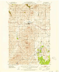
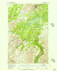
(23)- 1950 Map of Spokane NE, 1952 Print
 1950 Spokane NE1952 Print · USGSSpokane and its eastern valleys are captured here at a peak of rail and aviation development in the early fifties. Genealogists and local historians can trace family plots and school districts from Hillyard Cemeteries to the Hutton Settlement and Felts Field.2 unique versions available
 - 1950 Map of Spokane SE, 1952 Print
 1950 Spokane SE1952 Print · USGSSpokane and the surrounding prairies and mountains are captured here in the early postwar years as rural crossroads were still the heart of the community. Genealogists and historians can locate Moran Cem, the Grange Hall, and several local schools like Sunnyside Sch and Adams Sch.2 unique versions available
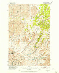
 - 1950 Map of Mt Spokane, 1952 Print
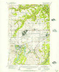
 1950 Mt Spokane1952 Print · USGSThe Washington-Idaho borderlands in the early fifties reveal a landscape of high summits and quiet lake basins. Genealogists and local historians can trace rural school districts like Kit Carson School and small community hubs such as Inland Grange and Peone.3 unique versions available
 - 1950 Map of Spokane SW, 1952 Print
 1950 Spokane SW1952 Print · USGSThe outskirts of mid-century Spokane reveal a busy intersection of major railroads and rural community life on the edge of Moran Prairie. Genealogists can locate family landmarks like Windsor School, Glenora Church, and several grange halls serving the farms along LATAH CREEK.
 - 1950 Map of Spokane NW, 1952 Print
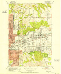
 1950 Spokane NW1952 Print · USGSSpokane enters the early fifties as a major military and rail hub, with neighborhoods expanding across the Spokane River. Genealogists and historians can locate legacy institutions like Gonzaga University, George Wright Air Force Base, and Holy Cross Cemetery.2 unique versions available
 - 1950 Map of Spokane, 1955 Print
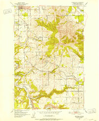
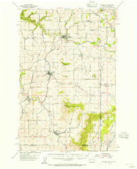
 1950 Spokane1955 Print · USGSSpokane was a bustling rail and aviation hub during the early fifties, caught in a moment of rapid post-war expansion. Genealogists and local historians can trace family roots through numerous parish schools, cemeteries like Holy Cross Cem, and outlying settlements such as Marshall and Pleasant Prairie.2 unique versions available
 - 1950 Map of Clayton, 1970 Print
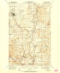
 1950 Clayton1970 Print · USGSThe Stevens and Spokane county line in the mid-twentieth century shows a landscape of river-fed prairies and mountain peaks. Genealogists can locate family landmarks like Haines Ranch, Williams Valley Cem, and the Fort Spokane Historic Site.
 - 1951 Map of Deer Park
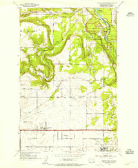
 1951 Deer Park1951 Print · USGSSpokane County's northern agricultural and industrial landscapes are captured here during the post-war era. Genealogists and researchers can trace the rural church and school networks at Wild Rose Ch, Mead, and the Peone-Foothills Grange.
 - 1951 Map of Greenacres
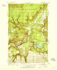
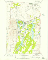
 1951 Greenacres1951 Print · USGSThe Spokane Valley at the mid-century shows a busy corridor of rail lines and new post-war industry. Researchers can trace family roots at Saltese Cem, explore the early footprint of the Naval Supply Depot, or locate vanished stations along the Spokane International railroad.2 unique versions available
 - 1953 Map of Reardan, 1954 Print
 1953 Reardan1954 Print · USGSThe Lincoln County wheat country near the Spokane border is captured here during the early fifties as the region's rural social life thrived. Researchers can trace the rail-and-road network connecting Reardan and Edwall, finding local landmarks like the Pleasant View Cem and West Deep Creek Grange.2 unique versions available
 - 1953 Map of Wellpinit, 1955 Print
 1953 Wellpinit1955 Print · USGSThe Spokane Indian Reservation and the rugged Stevens County hills come to life in the early fifties. Genealogists and historians can locate St Joseph Ch, the Wellpinit settlement, and local landmarks like Little Chamokane Falls.3 unique versions available
 - 1954 Map of Airway Heights, 1955 Print
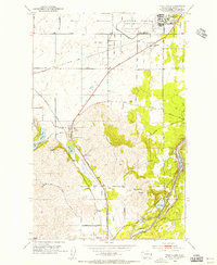
 1954 Airway Heights1955 Print · USGSAirway Heights and the surrounding West Plains are captured in the mid-fifties, just as the region’s aviation and military identity was taking hold. Genealogists and local historians can locate early landmarks like the Warsaw School, Stevens Township Hall, and the original footprint of Fairchild Air Force Base.
 - 1954 Map of Medical Lake, 1956 Print
 1954 Medical Lake1956 Print · USGSSpokane County's institutional and military landscape comes into focus during the mid-fifties. Researchers can trace the extensive grounds of Eastern State Hospital or locate the sprawling Fairchild Air Force Base and the rail-stop at Espanola.
 - 1954 Map of Medical Lake, 1956 Print
 1954 Medical Lake1956 Print · USGSSpokane County's military and institutional landscape is captured here during the mid-fifties, dominated by massive airfields and state facilities. Genealogists and historians can trace Fairchild Air Force Base, the Deno School, and early burial sites like Greenwood Prairie Cem.2 unique versions available
 - 1954 Map of Cheney, 1956 Print
 1954 Cheney1956 Print · USGSEastern Washington in the mid-fifties is captured here as a major railroad junction and home to the Eastern Washington College of Education. Genealogists and historians can trace defunct rural sites like the Harmony School or find family landmarks near Williams Lake and Fairview Cemetery.3 unique versions available
 - 1954 Map of Spangle, 1956 Print
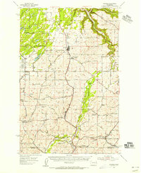 1954 Spangle1956 Print · USGSSoutheast of Spokane in the 1950s, this area reveals a dense network of early Pacific Northwest rail lines and fading rural school districts. Researchers can find grain elevators along the Great Northern and trace defunct sites like Buckeye Sch (Aband).2 unique versions available
 - 1954 Map of Four Lakes, 1956 Print
 1954 Four Lakes1956 Print · USGSSpokane County's aviation and rail corridors are at their height in the mid-1950s, bridging the gap between the city and the grain country. Researchers can trace family sites near Green Mound Cemetery or locate the old whistle stops of Hayford and Scribner.
 - 1954 Map of Sprague, 1956 Print
 1954 Sprague1956 Print · USGSEastern Washington’s Channeled Scablands are captured in the mid-1950s, showing a complex network of four major railroads crossing the rocky terrain. Genealogists and rail historians can trace the foundations of Sprague, the community at Fishtrap, and the Aban'd Sch near Tyler.2 unique versions available
 - 1954 Map of Deep Creek, 1956 Print
 1954 Deep Creek1956 Print · USGSSpokane County's transition from agricultural prairie to military hub is evident here during the mid-fifties. Researchers can trace family history through the Greenwood Prairie Cem and Indian Prairie School, or examine the early layout of Fairchild Air Force Base.
 - 1954 Map of Fairfield, 1956 Print
 1954 Fairfield1956 Print · USGSEastern Washington's agricultural heartland is documented here in the mid-fifties, featuring a dense network of rail lines and grain-country settlements. Trace the routes of the Union Pacific and visit sites like Fairfield, Latah, and the McIntosh Grange.3 unique versions available
 - 1955 Map of Spokane, 1965 Print
 1955 Spokane1965 Print · USGSInland Empire life in the fifties and sixties centers on the growth of Spokane and the heavy mining industry of northern Idaho. Trace mid-century landmarks like Fairchild Air Force Base, the Bunker Hill Mine, and early campuses such as Gonzaga University.2 unique versions available
 - 1958 Map of Spokane
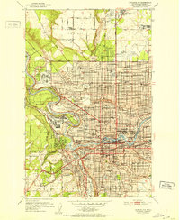
 1958 Spokane1958 Print · USGSThe Inland Empire is shown at a mid-century peak of industrial and military activity, from the rail hubs of Spokane to the deep silver mines of northern Idaho. Researchers can trace the sprawling rail lines of the Union Pacific RR or locate landmarks like Fairchild Air Force Base and the Bunker Hill Smelter & Mine.
 - 1958 Map of Sandpoint, 1966 Print
 1958 Sandpoint1966 Print · USGSThe Idaho Panhandle and Northeast Washington are shown here in the late fifties, when timber and hydroelectric power drove the local economy. Trace family roots in rail-side towns like Cusick or Metaline Falls, and locate landmarks like the Albeni Falls Dam or Falls Ranger Station.2 unique versions available
End of results
Showing maps 1-23 of 23
Top cities of Spokane County
- Spokane historical maps
- Spokane Valley historical maps
- Cheney historical maps
- Liberty Lake historical maps
- Airway Heights historical maps
- Colbert historical maps
See more
Frequently asked questions
- What are the different types of historical maps available for Spokane County?
- What is the oldest map of Spokane County?
- Where can I purchase historical maps of Spokane County for my home or office?
- Where can I download high-res historical maps of Spokane County?
- Are there historical topographic maps available for Spokane County?
- Is there historical aerial imagery available for Spokane County?
- Where are historical maps of Spokane County sourced from?