1960s Maps of Spokane County, Washington
Explore 14 historic maps of Spokane County from the 1960s. These maps offer a rare glimpse into what life looked like during the 1960s — showing old roads, neighborhoods, homes, and landmarks that have changed or disappeared over time.
Whether you're researching your family's past, planning a metal detecting trip, or studying how Spokane County's landscape evolved across the 1960s, these high-resolution maps are a powerful tool for exploring the history of this region.
- Focus on a specific era: All maps on this page are from the 1960s, giving you a focused view of this time period.
- See what’s changed: Compare century-old streets, trails, and buildings to today's modern landscape using overlays and satellite layers.
- Research with precision: Use these maps for genealogy, historical research, land use analysis, or educational projects.
- View, download, or print: Maps are fully viewable online in high resolution, and can be downloaded or printed for your own records.
Start exploring Spokane County's history through authentic maps from the 1960s. This is your window into the past.
Spokane County, WA maps
(14)- 1963 Map of Sandpoint
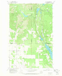
 1963 Sandpoint1963 Print · USGSNorthern Idaho and eastern Washington are shown in the early sixties as a high-country network of timber, mining, and rail. Genealogists and historians can trace the Great Northern line through Metaline Falls, Bonners Ferry, and past the Finch Mine.
 - 1963 Map of Four Lakes, 1964 Print
 1963 Four Lakes1964 Print · USGSSpokane County's aviation and rail infrastructure are on full display in the early 1960s, from the runways of Geiger Field to the surrounding hills. Genealogists and researchers can trace the settlement patterns at Four Lakes, Hayford, and old burial sites like Green Mound Cem.
 - 1963 Map of Medical Lake, 1964 Print
 1963 Medical Lake1964 Print · USGSSpokane County in the early 1960s reveals a landscape shaped by institutional growth and military expansion. Genealogists and historians can trace the footprints of Eastern State Hospital and Lakeland Village or locate burials at St Annes Cemetery.
 - 1963 Map of Spokane SW, 1964 Print
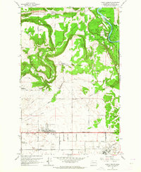
 1963 Spokane SW1964 Print · USGSThe southern fringes of Spokane and the rail-heavy valley at Marshall are captured here during the suburban expansion of the early sixties. Researchers can trace family history through local sites like Glenora Ch, Windsor Sch, and the Northwest Memorial Garden.
 - 1963 Map of Deep Creek, 1964 Print
 1963 Deep Creek1964 Print · USGSSpokane County's transition from rural prairie to a major military hub is captured here in the early 1960s. Genealogists and local historians can trace legacy sites like Greenwood Prairie, Botten Sch, and the grounds of Spokane Battlefield State Park.
 - 1963 Map of Spokane SE, 1964 Print
 1963 Spokane SE1964 Print · USGSSpokane's southern outskirts and the Moran Prairie were characterized by broadcasting hubs and hilltop ranches in the 1960s. Genealogists can locate family landmarks like Moran Cem or the Morning Star Ranch while tracing the Old Railroad Grade.
 - 1963 Map of Airway Heights, 1964 Print
 1963 Airway Heights1964 Print · USGSWestern Spokane County's aviation and military landscape is captured here during the mid-sixties growth of the Inland Empire. Researchers can trace the development of Airway Heights and Fairchild Air Force Base alongside rural landmarks like Stevens Township Hall and Sunset Sch.
 - 1963 Map of Spokane NW, 1964 Print
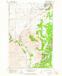
 1963 Spokane NW1964 Print · USGSSpokane emerges as a major Inland Empire rail and educational hub in the early sixties. Genealogists and researchers can trace the city's growth from Five Mile Prairie down to the historic Browne Addition, locating Fort Wright and dozens of neighborhood schools.
 - 1963 Map of Spokane NE, 1964 Print
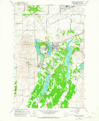
 1963 Spokane NE1964 Print · USGSSpokane in the early sixties was a bustling hub of rail transport and suburban growth along the river. Genealogists and local historians can trace the foundations of Millwood, the expansive Hutton Settlement, and the runways of Felts Field.
 - 1965 Map of Deer Lake, 1967 Print
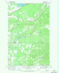
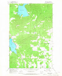 1965 Deer Lake1967 Print · USGSIn the mid-1960s, this area on the Stevens and Spokane county line was a hub of mineral extraction and rural life. Researchers can trace historic industry at Little King Mines and Claypits, or locate family sites near Zion Hill Cem.3 unique versions available
 - 1968 Map of Fan Lake, 1971 Print
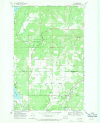
 1968 Fan Lake1971 Print · USGSSpokane County and its neighbors meet at the edge of the Washington highlands in the late sixties, where timber and water defined the local economy. Genealogists and researchers can trace family lands along Davis Road or locate landmarks like the Grange Hall and Camp Reed.2 unique versions available
 - 1968 Map of Camden, 1971 Print
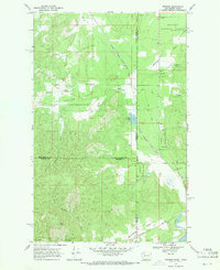
 1968 Camden1971 Print · USGSPend Oreille and Spokane counties are captured here in the late sixties as the Great Northern corridor winds through the valley. Researchers can trace family history through the Elk Cem No 2 and local landmarks like the Grange Hall and the community of Scotia.4 unique versions available
 - 1968 Map of Elk, 1971 Print
 1968 Elk1971 Print · USGSThe timbered valleys of Pend Oreille and Spokane counties are captured here in the late sixties, where the Great Northern rail line meets the Little Spokane River. Genealogists and hikers can trace the original sites of Elk Cemetery No 1, Camp Joubert, and the Grange Hall.3 unique versions available
 - 1968 Map of Tweedie, 1971 Print
 1968 Tweedie1971 Print · USGSCrossing the Washington-Idaho border in the late sixties, this area shows a landscape of timberlands and small rail-side settlements. Genealogists and researchers can trace the rail corridor of the Milwaukee Road through Tweedie and Blanchard, or locate the Spring Valley Ch and family-named landmarks like McDonald Creek.3 unique versions available
End of results
Showing maps 1-14 of 14
Top cities of Spokane County
- Spokane historical maps
- Spokane Valley historical maps
- Cheney historical maps
- Liberty Lake historical maps
- Airway Heights historical maps
- Colbert historical maps
See more
Frequently asked questions
- What are the different types of historical maps available for Spokane County?
- What is the oldest map of Spokane County?
- Where can I purchase historical maps of Spokane County for my home or office?
- Where can I download high-res historical maps of Spokane County?
- Are there historical topographic maps available for Spokane County?
- Is there historical aerial imagery available for Spokane County?
- Where are historical maps of Spokane County sourced from?