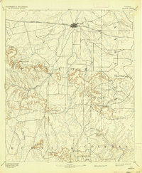
1954 Map of Abilene
USGS Topo · Published 1966This historical map portrays the area of Abilene in 1954, primarily covering Taylor County as well as portions of Throckmorton County, Stonewall County, Erath County, Callahan County, Comanche County, Brown County, Runnels County, Parker County, Palo Pinto County, Stephens County, Hamilton County, Coleman County, Haskell County, Jones County, Hood County, Bosque County, Young County, Eastland, and Shackelford County. Featuring a scale of 1:250000, this map provides a highly detailed snapshot of the terrain, roads, buildings, counties, and historical landmarks in the Abilene region at the time. Published in 1966, it is one of 2 known editions of this map due to revisions or reprints.
Find a feature on this map
143 named features on this map. Tap any name to fly to it.
Don’t see what you’re looking for? This feature index may not catch every label — zoom into the map to look around manually.
Map Details
Editions of this 1954 Abilene Map
2 editions found
Historical Maps of Peadenville Through Time
5 maps found