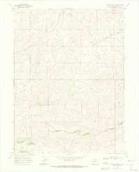
1969 Map of Adobe Springs
USGS Topo · Published 1972About this map
The high plains of Moffat County are defined by a network of drainage systems and vital water sources in this late 1960s study. The terrain is notably dissected by the Adobe Springs Creek and the West Prong, reflecting a landscape shaped by intermittent water flow. A single industrial marker, a Pipeline, cuts across the northwestern portion of the sheet, indicating the infrastructure for resource extraction or transport that often characterized this part of Colorado. Genealogy and local history researchers will find the Spring Creek Cem located in the northeastern section, a solitary point of recorded settlement or family heritage amidst the topographical contouring. Numerous points simply labeled Spring highlight the critical role of groundwater in this arid environment, scattered across the township boundaries of T. 9 N. and T. 8 N.
Find a feature on this map
7 named features on this map. Tap any name to fly to it.
Don’t see what you’re looking for? This feature index may not catch every label — zoom into the map to look around manually.
Map Details
Editions of this 1969 Adobe Springs Map
4 editions found
Other maps of this area

1916 · Craig
USGS Topo · 1:125,000

1954 · Vernal
USGS Topo · 1:250,000

1954 · Craig
USGS Topo · 1:250,000

1957 · Craig
USGS Topo · 1:250,000

1958 · Vernal
USGS Topo · 1:250,000

1958 · Craig
USGS Topo · 1:250,000

1958 · Maybell
USGS Topo · 1:62,500

1960 · Craig
USGS Topo · 1:250,000

1960 · Vernal
USGS Topo · 1:250,000

1962 · Craig
USGS Topo · 1:250,000