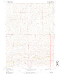
1969 Map of Adobe Springs
USGS Topo · Published 1985About this map
Adobe Springs and the drainage of Spring Creek define this high-altitude landscape in Moffat County as it was documented in 1968. The terrain is characterized by numerous seasonal water sources and intermittent flows, including the West Prong Spring Creek, which cut through the arid topography. This 1969 field-checked survey reveals a quiet, open region where human activity is limited to a few specific corridors. A long Pipeline traverses the northwestern section, cutting across the contour lines of the hills. The most significant historical landmark is the Spring Creek Cem, a lonely burial site located in the northeastern quadrant near the creek's upper reaches, providing a vital point of reference for genealogists and local historians studying the early ranching families of northwestern Colorado.
Find a feature on this map
7 named features on this map. Tap any name to fly to it.
Don’t see what you’re looking for? This feature index may not catch every label — zoom into the map to look around manually.
Map Details
Editions of this 1969 Adobe Springs Map
4 editions found
Other maps of this area

1916 · Craig
USGS Topo · 1:125,000

1954 · Vernal
USGS Topo · 1:250,000

1954 · Craig
USGS Topo · 1:250,000

1957 · Craig
USGS Topo · 1:250,000

1958 · Vernal
USGS Topo · 1:250,000

1958 · Craig
USGS Topo · 1:250,000

1958 · Maybell
USGS Topo · 1:62,500

1960 · Craig
USGS Topo · 1:250,000

1960 · Vernal
USGS Topo · 1:250,000

1962 · Craig
USGS Topo · 1:250,000