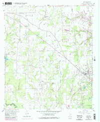
1958 Map of Alba
USGS Topo · Published 1987About this map
The town of Alba sits at a crossroads of late-1950s industry and agriculture along the border of Rains and Wood counties. This terrain is marked by a legacy of resource extraction, clearly indicated by the numerous Old Mining Area labels and several Oil Well sites scattered across the landscape. The transportation network is in transition, visible through the presence of an Old Railroad Grade and gravel pits, while the planned waters of the Lake Fork Reservoir suggest the coming transformation of the Mustang Creek bottomlands. Rural life is anchored by community landmarks such as Pilgrim Rest Ch, Salem Ch, and several family burial grounds including McCord Cem and Simpkins Cem. Smaller settlements like Ginger and Bright Star appear as clusters of homes along the backroads, maintaining their identity as the region's physical geography began to shift under new infrastructure projects.
Find a feature on this map
42 named features on this map. Tap any name to fly to it.
Don’t see what you’re looking for? This feature index may not catch every label — zoom into the map to look around manually.
Map Details
Editions of this 1958 Alba Map
3 editions found
Other maps of this area

1956 · Tyler
USGS Topo · 1:250,000

1956 · Emory
USGS Topo · 1:62,500

1958 · Arbala
USGS Topo · 1:24,000

1958 · Alba
USGS Topo · 1:24,000

1959 · Calvary
USGS Topo · 1:24,000

1959 · Golden
USGS Topo · 1:24,000

1959 · Grand Saline
USGS Topo · 1:24,000

1959 · Yantis
USGS Topo · 1:24,000

1959 · Grand Saline
USGS Topo · 1:62,500

1959 · Alba
USGS Topo · 1:62,500