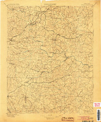
1897 Map of Amelia
USGS Topo · Published 1904About this map
The Appomattox River carves a winding path through central Virginia, serving as the historical boundary between several counties including Chesterfield, Amelia, and Dinwiddie. During the late nineteenth century, this landscape was defined by its railroad junctions and rural mill sites. The intersection of the Richmond and Danville RR and the Farmville and Powhatan RR at Mosley Junction represents a critical period of regional transport, supporting small settlements like Clayville, Skinquarter, and Chula.
Find a feature on this map
122 named features on this map. Tap any name to fly to it.
Don’t see what you’re looking for? This feature index may not catch every label — zoom into the map to look around manually.
Map Details
Editions of this 1897 Amelia Map
5 editions found

Other maps of this area

1890 · Goochland
USGS Topo · 1:125,000

1891 · Palmyra
USGS Topo · 1:125,000

1891 · Farmville
USGS Topo · 1:125,000

1892 · Goochland
USGS Topo · 1:125,000

1893 · Farmville
USGS Topo · 1:125,000

1894 · Bermuda Hundred
USGS Topo · 1:62,500

1894 · Petersburg
USGS Topo · 1:62,500

1894 · Richmond
USGS Topo · 1:62,500

1895 · Richmond
USGS Topo · 1:62,500

1895 · Palmyra
USGS Topo · 1:125,000