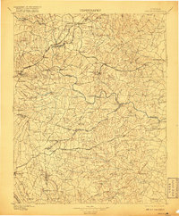
1897 Map of Amelia
USGS Topo · Published 1917About this map
Mosley Junction and the intersection of the Richmond and Danville R. R. and the Farmville and Powhatan R. R. define the industrial and transit character of this Central Virginia landscape. Surveyed in the late 19th century, the terrain is a complex network of creek drainage basins, including Deep Creek, Namozine Creek, and Swift Creek, which historically powered local commerce at sites like Giles Mill and Belmont Mill. Small rural hubs and post offices such as Skinquarter, Coalboro, and Hallsboro are connected by a series of established routes like the Goode Bridge Road and Namozine Road. The map captures the region when the Norfolk and Western R. R. served southern settlements like Church Road and Sutherland, illustrating a transition from river-based mill economies toward a rail-dominated trade system across Amelia, Chesterfield, and Dinwiddie counties.
Find a feature on this map
123 named features on this map. Tap any name to fly to it.
Don’t see what you’re looking for? This feature index may not catch every label — zoom into the map to look around manually.
Map Details
Editions of this 1897 Amelia Map
5 editions found

Other maps of this area

1890 · Goochland
USGS Topo · 1:125,000

1891 · Palmyra
USGS Topo · 1:125,000

1891 · Farmville
USGS Topo · 1:125,000

1892 · Goochland
USGS Topo · 1:125,000

1893 · Farmville
USGS Topo · 1:125,000

1894 · Bermuda Hundred
USGS Topo · 1:62,500

1894 · Petersburg
USGS Topo · 1:62,500

1894 · Richmond
USGS Topo · 1:62,500

1895 · Richmond
USGS Topo · 1:62,500

1895 · Palmyra
USGS Topo · 1:125,000