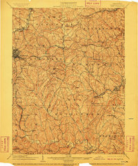
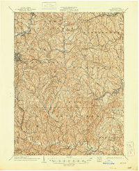
1904 Map of Amity
USGS Topo · Published 1910About this map
Washington stands as the primary hub of this rural landscape, situated where the historic National Road and the Washington and Williamsport Turnpike converge. The turn-of-the-century infrastructure is dominated by the Baltimore and Ohio Railroad and the Pennsylvania Railroad, which navigate the undulating terrain of the Ohio River Divide. This watershed boundary dictates the flow of numerous local waterways, such as Chartiers Creek and Tenmile Creek, which carve deep valleys across the central part of the county.
Find a feature on this map
98 named features on this map. Tap any name to fly to it.
Don’t see what you’re looking for? This feature index may not catch every label — zoom into the map to look around manually.
Map Details
Editions of this 1904 Amity Map
6 editions found
Other maps of this area

1900 · Masontown
USGS Topo · 1:62,500

1901 · Amity
USGS Topo · 1:62,500

1901 · Waynesburg
USGS Topo · 1:62,500

1902 · Brownsville
USGS Topo · 1:62,500

1903 · Masontown
USGS Topo · 1:62,500

1904 · Amity
USGS Topo · 1:62,500

1904 · Mc Keesport
USGS Topo · 1:62,500

1904 · Waynesburg
USGS Topo · 1:62,500

1904 · Carnegie
USGS Topo · 1:62,500

1904 · Burgettstown
USGS Topo · 1:62,500
Featured Places
- Washington, PA
- South Strabane Township, PA
- Mount Pleasant, South Strabane Township
- McGovern, Chartiers Township
- Bentleyville, PA