
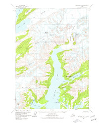
1960 Map of Anchorage A-2
USGS Topo · Published 1963About this map
Glacial ice and deep fjords dominate this coastal Alaskan landscape within the Chugach National Forest, as documented in the mid-20th century. Massive ice fields including Yale Glacier and Meares Glacier flow into the northern reaches of Unakwik Inlet and the Yale Arm. The map records a complex network of named ice masses such as Dartmouth Glacier, Ranney Glacier, and Brilliant Glacier carved between peaks like Mount Castner and Mount Grosvenor. In the south, the terrain transitions to the sheltered waters of Miners Bay, fed by the Miners River out of Miners Lake. The survey reflects a period of intensive photogrammetric mapping by the Geological Survey, capturing the precise shoreline of Jonah Bay and Wells Bay before significant modern shifts in glacial positions.
Find a feature on this map
22 named features on this map. Tap any name to fly to it.
Don’t see what you’re looking for? This feature index may not catch every label — zoom into the map to look around manually.
Map Details
Editions of this 1960 Anchorage A-2 Map
2 editions found
Other maps of this area

1951 · Seward
USGS Topo · 1:250,000

1951 · Anchorage
USGS Topo · 1:250,000

1951 · Seward D-2
USGS Topo · 1:63,360

1951 · Seward D-1
USGS Topo · 1:63,360

1951 · Seward D-3
USGS Topo · 1:63,360

1952 · Seward D-1
USGS Topo · 1:63,360

1952 · Seward D-3
USGS Topo · 1:63,360

1952 · Seward D-2
USGS Topo · 1:63,360

1953 · Seward
USGS Topo · 1:250,000

1959 · Seward
USGS Topo · 1:250,000