
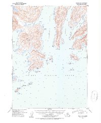
1952 Map of Seward D-2
USGS Topo · Published 1954About this map
Unakwik Inlet and Wells Bay carve deep into the coastline of Prince William Sound in this early 1950s hydrographic and topographic study. The landscape is defined by its maritime isolation, where human presence is marked only by small clusters of cabins on Axel Lind Island and Olsen Island. A notable point of historical interest is Kiniklik (Abandoned), situated near Kiniklik Island, serving as a silent indicator of shifting settlement patterns along the northern sound. This map captures the coastal geometry of the Chugach National Forest before modern development, detailing numerous inlets like Cedar Bay, Granite Bay, and Schoppe Bay. The bathymetric data provided for these waters illustrates the varied depths surrounding Fairmount Island and the smaller Jenny Islands, reflecting the era's reliance on maritime travel for regional access.
Find a feature on this map
31 named features on this map. Tap any name to fly to it.
Don’t see what you’re looking for? This feature index may not catch every label — zoom into the map to look around manually.
Map Details
Editions of this 1952 Seward D-2 Map
2 editions found
Other maps of this area

1951 · Seward
USGS Topo · 1:250,000

1951 · Anchorage
USGS Topo · 1:250,000

1951 · Seward D-2
USGS Topo · 1:63,360

1951 · Seward D-1
USGS Topo · 1:63,360

1951 · Seward D-3
USGS Topo · 1:63,360

1951 · Seward C-1
USGS Topo · 1:63,360

1951 · Seward C-3
USGS Topo · 1:63,360

1951 · Seward C-2
USGS Topo · 1:63,360

1952 · Seward C-1
USGS Topo · 1:63,360

1952 · Seward D-1
USGS Topo · 1:63,360