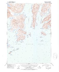
1952 Map of Seward D-2
USGS Topo · Published 1954About this map
Prince William Sound dominates this mid-century maritime survey, revealing the intricate coastline of south-central Alaska during a period of remote coastal habitation. The map documents scattered cabins and small settlements like Kiniklik on the mainland, alongside evidence of coastal life on Olsen Island and Axel Lind Island. These outposts represent the human footprint in the Chugach National Forest before more modern infrastructure arrived. The waters of Unakwik Inlet, Wells Bay, and Eaglek Bay are charted with soundings, while distinctive topographic features like Pt Pellew and Fairmount Pt define the navigation of the sound. This survey captures a specific era of Alaskan coastal history, noting isolated landmarks such as Birch, India, and Quote that likely served as local navigation or survey points for mariners and residents alike.
Find a feature on this map
46 named features on this map. Tap any name to fly to it.
Don’t see what you’re looking for? This feature index may not catch every label — zoom into the map to look around manually.
Map Details
Editions of this 1952 Seward D-2 Map
2 editions found

Other maps of this area

1951 · Seward
USGS Topo · 1:250,000

1951 · Anchorage
USGS Topo · 1:250,000

1951 · Seward D-2
USGS Topo · 1:63,360

1951 · Seward D-1
USGS Topo · 1:63,360

1951 · Seward D-3
USGS Topo · 1:63,360

1951 · Seward C-1
USGS Topo · 1:63,360

1951 · Seward C-3
USGS Topo · 1:63,360

1951 · Seward C-2
USGS Topo · 1:63,360

1952 · Seward C-1
USGS Topo · 1:63,360

1952 · Seward D-1
USGS Topo · 1:63,360