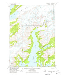
1960 Map of Anchorage A-2
USGS Topo · Published 1977About this map
Unakwik Inlet dominates this coastal survey, where the deep waters of Prince William Sound meet the advancing ice of the Chugach National Forest. The landscape is defined by massive tidal glaciers, including Yale Glacier and Meares Glacier, which feed into the narrow northern reaches of the Yale Arm and Harvard Arm. The topography transitions sharply from sea level to high alpine peaks like Mount Castner and Mount Grosvenor, illustrating the raw glaciated environment of the mid-20th century. Evidence of coastal hydrology and drainage is seen along the Miners River as it flows from Miners Lake into Miners Bay. This 1960 field study, compiled from aerial photography, provides a clear view of these glacial positions and coastal features before decades of modern environmental change. Other significant waterways include Jonah Bay and Wells Bay, tucked between the slopes of the Dora Keen Range.
Find a feature on this map
23 named features on this map. Tap any name to fly to it.
Don’t see what you’re looking for? This feature index may not catch every label — zoom into the map to look around manually.
Map Details
Editions of this 1960 Anchorage A-2 Map
2 editions found

Other maps of this area

1951 · Seward
USGS Topo · 1:250,000

1951 · Anchorage
USGS Topo · 1:250,000

1951 · Seward D-2
USGS Topo · 1:63,360

1951 · Seward D-1
USGS Topo · 1:63,360

1951 · Seward D-3
USGS Topo · 1:63,360

1952 · Seward D-1
USGS Topo · 1:63,360

1952 · Seward D-3
USGS Topo · 1:63,360

1952 · Seward D-2
USGS Topo · 1:63,360

1953 · Seward
USGS Topo · 1:250,000

1959 · Seward
USGS Topo · 1:250,000