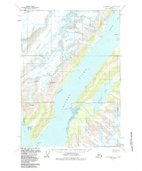
1960 Map of Anchorage A-3
USGS Topo · Published 1987About this map
College Fiord dominates this maritime landscape within the Chugach National Forest, where a network of tidewater and hanging glaciers defines the coast. Names reflecting the Ivy League and elite women's colleges of the East Coast, such as Harvard Arm, Yale Arm, Bryn Mawr Glacier, Vassar Glacier, and Wellesley Glacier, underscore the early 20th-century exploration and naming traditions in this region. The map captures a dynamic glacial environment, showing the vast ice fields of the Barry Glacier and Coxe Glacier pressing toward the sea. Inland, the freshwater systems of Coghill Lake and the Coghill River provide a sharp contrast to the massive ice flows. A few isolated points of human presence, such as Cabin and Coghill Pt, mark the sparsely settled coastline between high peaks like Mt Emerson and Mt Coville.
Find a feature on this map
35 named features on this map. Tap any name to fly to it.
Don’t see what you’re looking for? This feature index may not catch every label — zoom into the map to look around manually.
Map Details
Editions of this 1960 Anchorage A-3 Map
2 editions found

Other maps of this area

1951 · Seward
USGS Topo · 1:250,000

1951 · Anchorage
USGS Topo · 1:250,000

1951 · Seward D-2
USGS Topo · 1:63,360

1951 · Seward D-4
USGS Topo · 1:63,360

1951 · Seward D-3
USGS Topo · 1:63,360

1952 · Seward D-3
USGS Topo · 1:63,360

1952 · Seward D-4
USGS Topo · 1:63,360

1952 · Seward D-2
USGS Topo · 1:63,360

1953 · Seward
USGS Topo · 1:250,000

1959 · Seward
USGS Topo · 1:250,000