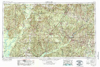
1953 Map of Andalusia
USGS Topo · Published 1973About this map
Alabama River and Conecuh River drain the heart of South Alabama, defining a landscape of timberlands and fertile plains in the mid-1950s. The region is anchored by a dense network of timber and transit hubs like Andalusia, Brewton, and Evergreen, all connected by the dominant Louisville & Nashville RR. Extensive public lands, including the Conecuh National Forest and Little River State Forest, mark the southern borderlands along the Florida line. To the west, the winding paths of the Tombigbee River and Mobile River converge amidst a complex of backwaters such as Tensaw Lake and Three Rivers Lake. This era shows the early development of local industry, from the Oil Field near the Escambia River to the scattered aviation facilities like Skelly AAF, while smaller settlements such as Frisco City and Castleberry serve as vital links in the rural agricultural economy.
Find a feature on this map
160 named features on this map. Tap any name to fly to it.
Don’t see what you’re looking for? This feature index may not catch every label — zoom into the map to look around manually.
Map Details
Editions of this 1953 Andalusia Map

Other maps of this area

1941 · Bay Minette
USGS Topo · 1:62,500

1941 · Creola
USGS Topo · 1:62,500

1941 · Century
USGS Topo · 1:62,500

1942 · Enterprise
USGS Topo · 1:125,000

1942 · Perdido
USGS Topo · 1:62,500

1942 · Dyas
USGS Topo · 1:62,500

1943 · Creola
USGS Topo · 1:62,500

1943 · Century
USGS Topo · 1:62,500

1943 · Bay Minette
USGS Topo · 1:62,500

1943 · Jay
USGS Topo · 1:62,500