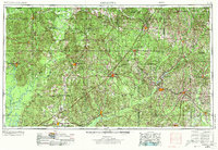
1953 Map of Andalusia
USGS Topo · Published 1973About this map
The Alabama River and Tombigbee River define the western reaches of this 1950s survey, a landscape where river navigation and rail transport intersect. Major rail lines including the Louisville & Nashville and Seaboard Coast Line connect established regional hubs like Andalusia, Greenville, and Brewton. This period captures the region's agricultural and industrial infrastructure, notably the Atmore State Prison Farm and the conservation lands of the Little River State Forest. Numerous waterways, such as the Sepulga River and Pigeon Creek, feed the larger river basins, illustrating the drainage patterns vital to the area's timber and farming history. Small settlements like Monroeville and Georgiana serve as nodes in a dense network of secondary roads and forest tracts that characterize the heart of South Alabama during the mid-century.
Find a feature on this map
67 named features on this map. Tap any name to fly to it.
Don’t see what you’re looking for? This feature index may not catch every label — zoom into the map to look around manually.
Map Details
Editions of this 1953 Andalusia Map

Other maps of this area

1941 · Bay Minette
USGS Topo · 1:62,500

1941 · Creola
USGS Topo · 1:62,500

1941 · Century
USGS Topo · 1:62,500

1942 · Enterprise
USGS Topo · 1:125,000

1942 · Perdido
USGS Topo · 1:62,500

1942 · Dyas
USGS Topo · 1:62,500

1943 · Creola
USGS Topo · 1:62,500

1943 · Century
USGS Topo · 1:62,500

1943 · Bay Minette
USGS Topo · 1:62,500

1943 · Jay
USGS Topo · 1:62,500