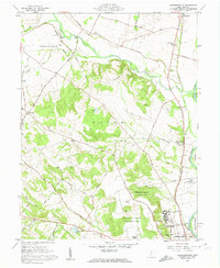
1961 Map of Andersonville
USGS Topo · Published 1962About this map
The Scioto River valley defines this Ross County landscape, showing a transition from the agricultural bottomlands of Green township to the high, rolling terrain of Union. At the southern edge of the sheet, the VA Hospital and the nearby Mound City Group National Monument anchor the area near the river. The map details an era when the local infrastructure was deeply tied to the land, featuring numerous country churches like Spring Bank Ch and Dry Run Chapel, and small rural burial grounds including Minear Cem and Bowdle Cem. A Covered Bridge spans Deer Creek in the north, while the B & O RR tracks follow the western bank of the river through Andersonville. Significant acreage is dedicated to the Pleasant Valley Wildlife Area, marking a shift toward conservation alongside established landmarks like the County Fairgrounds.
Find a feature on this map
56 named features on this map. Tap any name to fly to it.
Don’t see what you’re looking for? This feature index may not catch every label — zoom into the map to look around manually.
Map Details
Editions of this 1961 Andersonville Map
4 editions found
Other maps of this area

1906 · Chillicothe
USGS Topo · 1:62,500

1908 · Chillicothe
USGS Topo · 1:62,500

1911 · Era
USGS Topo · 1:62,500

1912 · Roxabell
USGS Topo · 1:62,500

1913 · Era
USGS Topo · 1:62,500

1914 · Roxabell
USGS Topo · 1:62,500

1914 · Circleville
USGS Topo · 1:62,500

1943 · Era
USGS Topo · 1:62,500

1943 · Circleville
USGS Topo · 1:62,500

1944 · Roxabell
USGS Topo · 1:62,500