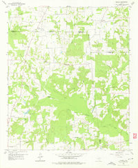
1958 Map of Arbala
USGS Topo · Published 1976About this map
The rolling East Texas countryside where Hopkins, Rains, and Wood Counties meet is defined by a dense network of creek branches and small agricultural settlements. Small communities like Arbala and Bonanza anchor the northern reaches of this landscape, which is heavily dissected by the tributaries of the Lake Fork Creek and Elm Creek. The topography reveals a rural society built around local institutions, with several country churches such as Freedom Ch and Macedonia Ch serving as focal points for the surrounding farmsteads.
Find a feature on this map
38 named features on this map. Tap any name to fly to it.
Don’t see what you’re looking for? This feature index may not catch every label — zoom into the map to look around manually.
Map Details
Editions of this 1958 Arbala Map
4 editions found
Other maps of this area

1953 · Texarkana
USGS Topo · 1:250,000

1956 · Texarkana
USGS Topo · 1:250,000

1956 · Tyler
USGS Topo · 1:250,000

1956 · Emory
USGS Topo · 1:62,500

1958 · Arbala
USGS Topo · 1:24,000

1958 · Alba
USGS Topo · 1:24,000

1959 · Calvary
USGS Topo · 1:24,000

1959 · Yantis
USGS Topo · 1:24,000

1959 · Alba
USGS Topo · 1:62,500

1962 · Miller Grove
USGS Topo · 1:24,000