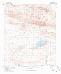
1957 Map of Arch
USGS Topo · Published 1984About this map
Salt Lake and Little Salt Lake anchor the center of this 1957 survey of the High Plains borderlands, where the Portales Valley cuts across the state line between New Mexico and Texas. The landscape is defined by large-scale ranching operations and the infrastructure of the cattle industry, with named holdings such as Coldwater Ranch, Phillips Ranch, and Nickles Ranch dotting the terrain. The small community of Arch serves as a local hub near the center of the sheet, while numerous windmills and wells indicate the vital importance of groundwater in this arid environment.
Find a feature on this map
30 named features on this map. Tap any name to fly to it.
Don’t see what you’re looking for? This feature index may not catch every label — zoom into the map to look around manually.
Map Details
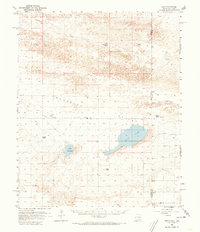
Editions of this 1957 Arch Map
3 editions found
Other maps of this area

1954 · Clovis
USGS Topo · 1:250,000

1954 · Brownfield
USGS Topo · 1:250,000

1957 · Portair
USGS Topo · 1:62,500

1957 · Clovis
USGS Topo · 1:62,500

1957 · Arch
USGS Topo · 1:62,500

1957 · Portales
USGS Topo · 1:62,500

1958 · Brownfield
USGS Topo · 1:250,000

1958 · Clovis
USGS Topo · 1:250,000

1962 · Brownfield
USGS Topo · 1:250,000

1962 · Stegall
USGS Topo · 1:24,000