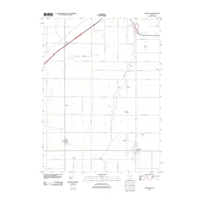
2010 Map of Arlington
USGS Topo · Published 2010About this map
Arlington and Jenera anchor this rural landscape in Hancock County, Ohio, characterized by a dense network of township roads and agricultural lands. The terrain is defined by the winding paths of Eagle Creek and Tiderishi Creek, which dictate the placement of early burial grounds and modern recreation sites like the Sycamore Springs Golf Course. A high concentration of family and community burial sites, including Saint Pauls Cemetery, Trinity Cemetery, and Bishop Cemetery, provides a clear map of local genealogy and settlement patterns. The presence of both the Jenera Post Office and small aviation facilities like Alge Airport and Ferrell Airport illustrates the evolution of rural infrastructure. Farther north, Camp Berry occupies the woodland near the banks of Eagle Creek, highlighting the area's use for outdoor community space amidst the grid of farm roads and drainage runs.
Find a feature on this map
57 named features on this map. Tap any name to fly to it.
Don’t see what you’re looking for? This feature index may not catch every label — zoom into the map to look around manually.
Map Details
Editions of this 2010 Arlington Map
This is the sole edition of this map. No revisions or reprints were ever made.
Other maps of this area

1903 · Findlay
USGS Topo · 1:62,500

1905 · Arlington
USGS Topo · 1:62,500

1907 · Bluffton
USGS Topo · 1:62,500

1907 · Arlington
USGS Topo · 1:24,000

1950 · Marion
USGS Topo · 1:250,000

1956 · Toledo
USGS Topo · 1:250,000

1960 · Rawson
USGS Topo · 1:24,000

1960 · Arlington
USGS Topo · 1:24,000
1960 · Findlay
USGS Topo · 1:24,000

1960 · Mt Blanchard
USGS Topo · 1:24,000