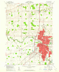
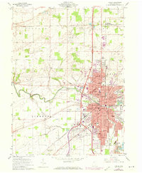
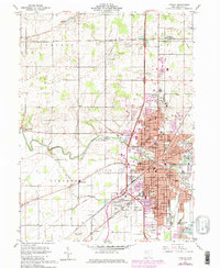
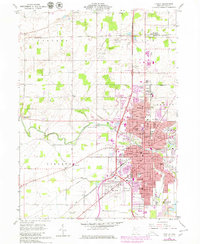
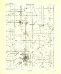
1960 Map of Findlay
USGS Topo · Published 1962About this map
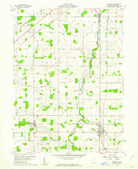
The Blanchard River defines the central topography of this 1960 survey, flowing through the heart of Findlay and connecting the city's parks, institutional centers, and industrial corridors. The landscape is a study in mid-century growth, featuring established neighborhoods such as West Park and the distinct community of Mortimer (North Findlay). Civic and social infrastructure is dense, including Findlay College, the Courthouse, and the County Fairground. Transportation and industry drive the local economy, visible through the extensive Tank Farm sites, active Quarry locations, and the confluence of the New York Chicago and St Louis RR, the Baltimore and Ohio RR, and the New York Central RR. For those tracing local heritage, several smaller landmarks like Aurand Cem, Pleasant Hill Ch, and numerous neighborhood schools like Firmin Sch and Jefferson Sch provide specific points of geographic reference.
Find a feature on this map
82 named features on this map. Tap any name to fly to it.
Don’t see what you’re looking for? This feature index may not catch every label — zoom into the map to look around manually.
Map Details
Editions of this 1960 Findlay Map
4 editions found
Other maps of this area
1903 · Findlay
USGS Topo · 1:62,500

1905 · Arlington
USGS Topo · 1:62,500

1907 · Bluffton
USGS Topo · 1:62,500

1907 · Arlington
USGS Topo · 1:24,000

1950 · Marion
USGS Topo · 1:250,000

1956 · Toledo
USGS Topo · 1:250,000
1960 · Rawson
USGS Topo · 1:24,000
1960 · Bloomdale
USGS Topo · 1:24,000
1960 · North Baltimore
USGS Topo · 1:24,000
1960 · Arlington
USGS Topo · 1:24,000