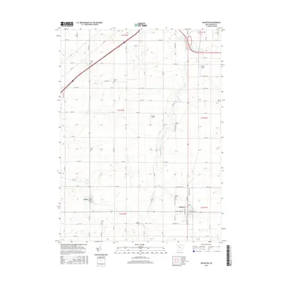
2016 Map of Arlington
USGS Topo · Published 2016About this map
Arlington and Jenera serve as the primary hubs in this part of Hancock County, where the landscape is defined by the steady flow of Eagle Creek and its tributaries. This 2016 survey highlights a predominantly agricultural region organized into a strict grid of township and county roads. Local history and genealogy are well-preserved through numerous rural burial grounds, including the Trinity Cem, Saint Pauls Cem, and Bishop Cem. These sites, often situated near township lines or small watercourses like Aurand Run and Tiderishi Cr, provide a spatial record of early settlement patterns in the area. Aviation footprints are also visible with the inclusion of Schaller Airport and Ferrell Airport, reflecting the persistence of private airfields in this rural Ohio corridor. The map effectively documents the street layouts of the incorporated villages, from N Main St in Arlington to the residential blocks of Jenera.
Find a feature on this map
121 named features on this map. Tap any name to fly to it.
Don’t see what you’re looking for? This feature index may not catch every label — zoom into the map to look around manually.
Map Details
Editions of this 2016 Arlington Map
This is the sole edition of this map. No revisions or reprints were ever made.
Other maps of this area

1903 · Findlay
USGS Topo · 1:62,500

1905 · Arlington
USGS Topo · 1:62,500

1907 · Bluffton
USGS Topo · 1:62,500

1907 · Arlington
USGS Topo · 1:24,000

1950 · Marion
USGS Topo · 1:250,000

1956 · Toledo
USGS Topo · 1:250,000

1960 · Rawson
USGS Topo · 1:24,000

1960 · Arlington
USGS Topo · 1:24,000
1960 · Findlay
USGS Topo · 1:24,000

1960 · Mt Blanchard
USGS Topo · 1:24,000