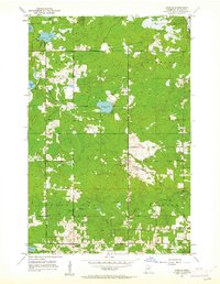
1953 Map of Arnold
USGS Topo · Published 1962About this map
The small community of Arnold serves as the focal point for this early 1950s survey of southern St. Louis County, where the landscape is defined by the transition from rural townships into the forested headwaters of the North Shore streams. Local infrastructure centers on rural education and faith, evidenced by the Lakewood Sch and Exeter Farms Ch in the southern reaches, while the northern sections are dominated by the woodland and water of Gnesen and Normanna townships. Numerous small bodies of water, including the centrally located Eagle Lake and the oddly shaped Horseshoe Lake, suggest a glaciated terrain heavily interspersed with marshes.
Find a feature on this map
29 named features on this map. Tap any name to fly to it.
Don’t see what you’re looking for? This feature index may not catch every label — zoom into the map to look around manually.
Map Details
Editions of this 1953 Arnold Map
5 editions found
Other maps of this area

1895 · Duluth
USGS Topo · 1:62,500

1953 · Lakewood
USGS Topo · 1:24,000

1953 · French River
USGS Topo · 1:24,000

1953 · Arnold
USGS Topo · 1:24,000

1953 · Duluth
USGS Topo · 1:24,000

1953 · Duluth Heights
USGS Topo · 1:24,000

1953 · Boulder Lake Reservoir
USGS Topo · 1:24,000

1953 · Fredenberg
USGS Topo · 1:24,000

1953 · Duluth
USGS Topo · 1:62,500

1953 · Ashland
USGS Topo · 1:250,000