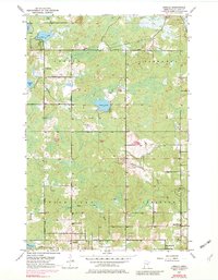
1953 Map of Arnold
USGS Topo · Published 1982About this map
Arnold anchors the southern portion of this St. Louis County survey, appearing as a focal point for the surrounding rural townships of Gnesen, Normanna, Rice Lake, and Lakewood. The landscape is defined by the headwaters of several prominent waterways, including the Lester River, the East Branch Amity Creek, and the French River, which carve through the terrain as they flow toward the Great Lakes basin. The 1950s cultural footprint is marked by community infrastructure such as the Town Hall, Gnesen Sch, and Lakewood Sch, reflecting the localized organization of these townships during the mid-twentieth century.
Find a feature on this map
29 named features on this map. Tap any name to fly to it.
Don’t see what you’re looking for? This feature index may not catch every label — zoom into the map to look around manually.
Map Details
Editions of this 1953 Arnold Map
5 editions found
Other maps of this area

1895 · Duluth
USGS Topo · 1:62,500

1953 · Lakewood
USGS Topo · 1:24,000

1953 · French River
USGS Topo · 1:24,000

1953 · Arnold
USGS Topo · 1:24,000

1953 · Duluth
USGS Topo · 1:24,000

1953 · Duluth Heights
USGS Topo · 1:24,000

1953 · Boulder Lake Reservoir
USGS Topo · 1:24,000

1953 · Fredenberg
USGS Topo · 1:24,000

1953 · Duluth
USGS Topo · 1:62,500

1953 · Ashland
USGS Topo · 1:250,000