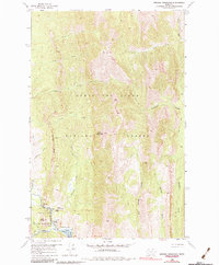
1958 Map of Arsenic Mountain
USGS Topo · Published 1984About this map
Arsenic Mountain dominates this high-altitude landscape where the Sun River cuts through the Southern Front of the Rockies. In the late 1950s, this area served as a critical intersection of wilderness management and recreation within the Lewis and Clark National Forest. The presence of the Sun River Game Preserve and the Sorrell Guest Resort suggests a mid-century economy built on conservation and seasonal tourism. Along the river banks near Gibson Reservoir, small outposts like White Cabin, KL Ranch, and the Sorrell Guest Resort provided access points for those navigating the extensive network of Pack Trails. The topography is marked by significant drainages such as Arsenic Creek and Blacktail Creek, which feed into the reservoir system behind the Reclamation Flats.
Find a feature on this map
29 named features on this map. Tap any name to fly to it.
Don’t see what you’re looking for? This feature index may not catch every label — zoom into the map to look around manually.
Map Details
Editions of this 1958 Arsenic Mountain Map
3 editions found
Other maps of this area

1903 · Saypo
USGS Topo · 1:125,000

1955 · Choteau
USGS Topo · 1:250,000

1957 · Choteau
USGS Topo · 1:250,000

1958 · Choteau
USGS Topo · 1:250,000

1958 · Ear Mountain
USGS Topo · 1:24,000

1958 · Our Lake
USGS Topo · 1:24,000

1958 · Sawtooth Ridge
USGS Topo · 1:24,000

1958 · Glenn Creek
USGS Topo · 1:24,000

1958 · Pretty Prairie
USGS Topo · 1:24,000

1958 · Gates Park
USGS Topo · 1:24,000