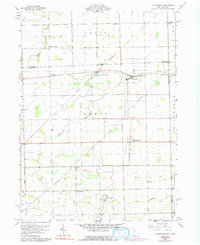
1960 Map of Assumption
USGS Topo · Published 1992About this map
The agricultural plains along the Lenawee and Fulton County line are documented here during a period of steady rural character. The settlement of Metamora serves as a local hub, situated where the Detroit Toledo and Ironton railroad line crosses Tenmile Creek. The landscape is defined by its rectilinear grid of section lines and township boundaries, including Royalton, Amboy, and Richfield. Genealogists will find several distinct burial grounds, such as Peebles Cem and Township Cem, which anchor the surrounding farmsteads. South of the village, smaller communities like Assumption and Lytton appear amidst a network of natural and man-made waterways, including the Metamora Reservoir and numerous drainage structures like the Mc Nett ditch. The presence of pipelines cutting diagonally across the section grid suggests the infrastructure development that paralleled the mid-century farming economy.
Find a feature on this map
34 named features on this map. Tap any name to fly to it.
Don’t see what you’re looking for? This feature index may not catch every label — zoom into the map to look around manually.
Map Details
Editions of this 1960 Assumption Map
Other maps of this area

1911 · Wauseon
USGS Topo · 1:62,500

1911 · Swanton
USGS Topo · 1:62,500

1913 · Wauseon
USGS Topo · 1:62,500

1914 · Swanton
USGS Topo · 1:62,500

1935 · Whitehouse
USGS Topo · 1:24,000

1935 · Berkey
USGS Topo · 1:24,000

1939 · Berkey
USGS Topo · 1:31,680

1939 · Blissfield
USGS Topo · 1:62,500
1940 · Whitehouse
USGS Topo · 1:31,680

1941 · Blissfield
USGS Topo · 1:62,500