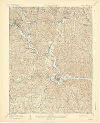
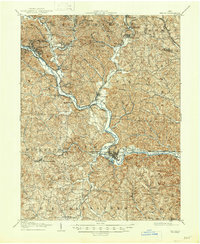
1905 Map of Athens
USGS Topo · Published 1929About this map
The Hocking River winds through the heart of this early 20th-century landscape, anchoring a network of coal and industrial settlements throughout Athens County. The convergence of multiple rail lines, including the Hocking Valley RR and the Kanawha and Michigan RR, highlights the era's reliance on heavy rail for moving resources from towns like Nelsonville, Buchtel, and Glouster. Smaller community centers such as Millfield, Chauncey, and New Marshfield are clearly defined, showing the distribution of the population along the river valley and its major tributaries like Sunday Creek and Monday Creek.
Find a feature on this map
72 named features on this map. Tap any name to fly to it.
Don’t see what you’re looking for? This feature index may not catch every label — zoom into the map to look around manually.
Map Details
Editions of this 1905 Athens Map
6 editions found
Other maps of this area

1903 · Athens
USGS Topo · 1:62,500

1904 · Zaleski
USGS Topo · 1:62,500

1904 · Chesterhill
USGS Topo · 1:62,500

1905 · Athens
USGS Topo · 1:62,500

1905 · Wilkesville
USGS Topo · 1:62,500

1906 · Chesterhill
USGS Topo · 1:62,500

1907 · Pomeroy
USGS Topo · 1:62,500

1907 · Keno
USGS Topo · 1:62,500

1907 · Zaleski
USGS Topo · 1:62,500

1907 · Logan
USGS Topo · 1:62,500