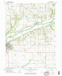
1962 Map of Attica
USGS Topo · Published 1964About this map
The Wabash River serves as the primary geographical anchor of this mid-century Indiana survey, marking the boundary between Warren and Fountain counties. Along its southern banks, the city of Attica is shown during a period of steady growth, featuring its local Riley Airfield and a cluster of cemeteries including Hatton Cem and the Ruppert Cem. The landscape is a mix of river bottomlands and agricultural uplands, carved by tributaries such as Big Shawnee Creek and the steep terrain of Opossum Hollow.
Find a feature on this map
42 named features on this map. Tap any name to fly to it.
Don’t see what you’re looking for? This feature index may not catch every label — zoom into the map to look around manually.
Map Details
Editions of this 1962 Attica Map
2 editions found
Other maps of this area

1942 · Otterbein
USGS Topo · 1:24,000

1951 · Otterbein
USGS Topo · 1:24,000

1953 · Danville
USGS Topo · 1:250,000

1955 · Danville
USGS Topo · 1:250,000

1956 · Danville
USGS Topo · 1:250,000

1958 · Stonebluff
USGS Topo · 1:24,000

1961 · Chatterton
USGS Topo · 1:24,000

1961 · Pine Village
USGS Topo · 1:24,000

1961 · Otterbein
USGS Topo · 1:24,000

1962 · Williamsport
USGS Topo · 1:24,000