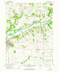
1962 Map of Attica
USGS Topo · Published 1964About this map
The Wabash River serves as the central artery of this Indiana landscape, dividing Warren and Fountain counties as it flows past the town of Attica. In the early 1960s, the region was defined by a mix of river-bottom agriculture and transportation infrastructure, with the Wabash Railroad tracing the northern bank. The terrain is marked by significant drainages such as Kickapoo Creek and Big Shawnee Creek, which carve through the till plains toward the river valley.
Find a feature on this map
42 named features on this map. Tap any name to fly to it.
Don’t see what you’re looking for? This feature index may not catch every label — zoom into the map to look around manually.
Map Details
Editions of this 1962 Attica Map
2 editions found
Other maps of this area

1942 · Otterbein
USGS Topo · 1:24,000

1951 · Otterbein
USGS Topo · 1:24,000

1953 · Danville
USGS Topo · 1:250,000

1955 · Danville
USGS Topo · 1:250,000

1956 · Danville
USGS Topo · 1:250,000

1958 · Stonebluff
USGS Topo · 1:24,000

1961 · Chatterton
USGS Topo · 1:24,000

1961 · Pine Village
USGS Topo · 1:24,000

1961 · Otterbein
USGS Topo · 1:24,000

1962 · Williamsport
USGS Topo · 1:24,000