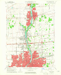
1964 Map of Aurora North
USGS Topo · Published 1965About this map
The Fox River corridor in the mid-1960s serves as the industrial and social spine of this Kane County region, anchoring the established centers of Batavia and Aurora. The landscape reflects a mix of civic institutions and specialized communities, most notably the sprawling Mooseheart campus and the Marmion Military Academy. Significant transportation infrastructure, including the Chicago Burlington And Quincy railroad and the East-West Tollway, illustrates the area's role as a major transit hub for both passengers and freight. Along the riverbanks, recreational and memorial sites like the Fabyan Forest Preserve and River Hills Memorial Park provide green space between the dense urban grids. Further west, the presence of the Aurora Airways Airport and the Aurora Downs racetrack highlights the diverse land use during this period of suburban expansion.
Find a feature on this map
95 named features on this map. Tap any name to fly to it.
Don’t see what you’re looking for? This feature index may not catch every label — zoom into the map to look around manually.
Map Details
Editions of this 1964 Aurora North Map
Other maps of this area

1892 · Joliet
USGS Topo · 1:62,500

1908 · Wheaton
USGS Topo · 1:62,500

1923 · Joliet
USGS Topo · 1:62,500

1925 · Yorkville
USGS Topo · 1:62,500

1932 · Geneva
USGS Topo · 1:62,500

1948 · Wheaton
USGS Topo · 1:62,500

1948 · Geneva
USGS Topo · 1:62,500

1949 · Geneva
USGS Topo · 1:24,000

1950 · Aurora North
USGS Topo · 1:24,000

1953 · Naperville
USGS Topo · 1:24,000