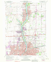
1964 Map of Aurora North
USGS Topo · Published 1983About this map
The Fox River corridor serves as the industrial and social spine of this mid-century landscape, connecting the growing cities of Aurora, Batavia, and Geneva. The riverfront is characterized by a mix of heavy industry and civic expansion, featuring numerous Gravel Pits and a Quarry alongside established landmarks like the Fabyan Forest Preserve and the Marmion Military Academy.
Find a feature on this map
120 named features on this map. Tap any name to fly to it.
Don’t see what you’re looking for? This feature index may not catch every label — zoom into the map to look around manually.
Map Details
Editions of this 1964 Aurora North Map
Other maps of this area

1892 · Joliet
USGS Topo · 1:62,500

1908 · Wheaton
USGS Topo · 1:62,500

1923 · Joliet
USGS Topo · 1:62,500

1925 · Yorkville
USGS Topo · 1:62,500

1932 · Geneva
USGS Topo · 1:62,500

1948 · Wheaton
USGS Topo · 1:62,500

1948 · Geneva
USGS Topo · 1:62,500

1949 · Geneva
USGS Topo · 1:24,000

1950 · Aurora North
USGS Topo · 1:24,000

1953 · Naperville
USGS Topo · 1:24,000