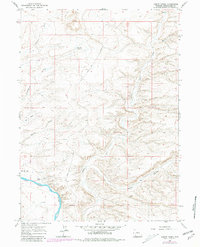
1961 Map of Austin Ranch
USGS Topo · Published 1981About this map
Austin Ranch and the level terrain of Manns Flat anchor the southwestern corner of this survey, where the Green River carves a sharp path through the high desert. The landscape is defined by the prominent Blue Rim escarpment, a massive landform that separates the higher plateau from the complex drainage networks of Alkali Creek and Scott Canyon to the east. The 1961 field check captures a period of early infrastructure development in Sweetwater County, marked by the presence of a Pipeline and the essential Blue Rim Road navigating the rim. Hydrological management is evidenced by the isolated Blue Rim Res No 1, while numerous ephemeral drainages like Twentyfive Mile Draw and Chris Wash illustrate the arid erosion patterns characteristic of this region before late-20th-century expansion.
Find a feature on this map
16 named features on this map. Tap any name to fly to it.
Don’t see what you’re looking for? This feature index may not catch every label — zoom into the map to look around manually.
Map Details
Editions of this 1961 Austin Ranch Map
2 editions found
Other maps of this area

1954 · Rock Springs
USGS Topo · 1:250,000

1958 · Rock Springs
USGS Topo · 1:250,000

1961 · Scott Spring
USGS Topo · 1:24,000

1961 · Peru
USGS Topo · 1:24,000

1961 · Austin Ranch
USGS Topo · 1:24,000

1961 · Stevens Flat
USGS Topo · 1:24,000

1961 · Green River
USGS Topo · 1:24,000

1961 · Bryan
USGS Topo · 1:24,000

1962 · Rock Springs
USGS Topo · 1:250,000

1963 · Big Island Bridge
USGS Topo · 1:24,000