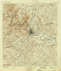
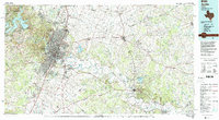
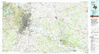
1985 Map of Austin
USGS Topo · Published 1985About this map
The Colorado River winds through the heart of the central Texas corridor during a period of significant regional expansion. This mid-1980s planimetric study highlights the sprawl of Austin as it stretches toward satellite communities like Round Rock, Pflugerville, and Buda. To the east, the landscape transitions from the urban density of Montopolis and the strategic expanse of Bergstrom Air Force Base into the agricultural and wooded reaches of Bastrop and Elgin. The rail network, featuring the Missouri Pacific and Southern Pacific, remains a critical component of the local infrastructure, connecting the capital to more rural outposts such as Mc Dade and Paige. Local landmarks like Mount Bonnell and Mount Larson punctuate the topography near Lake Austin, while the eastern portion of the map is defined by the massive Camp Swift Military Reservation and the protected lands of Bastrop State Park.
Find a feature on this map
158 named features on this map. Tap any name to fly to it.
Don’t see what you’re looking for? This feature index may not catch every label — zoom into the map to look around manually.
Map Details
Editions of this 1985 Austin Map
3 editions found
Historical Maps of Austin Through Time
6 maps found