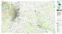
1985 Map of Austin
USGS Topo · Published 1992About this map
The Colorado River carves through this Central Texas landscape as the mid-1980s urban expansion begins to bridge the gap between Austin and its northern neighbor Round Rock. This survey highlights a critical period of infrastructure, showing the sprawling footprint of Bergstrom Air Force Base south of the city and the established residential enclaves of West Lake Hills and Rollingwood. To the west, the dammed waters of Lake Travis and Lake Austin define the edge of the Balcones Escarpment, while the eastern plains are characterized by a network of smaller agricultural communities like New Sweden, Cele, and Manda. The map provides a clear look at the region's rail heritage, featuring the Missouri Pacific RR and Southern Pacific RR corridors that helped shape these settlements. Further east, the Camp Swift Military Reservation and the loblolly pines of Bastrop State Park anchor the terrain before it reaches the Lee County line.
Find a feature on this map
174 named features on this map. Tap any name to fly to it.
Don’t see what you’re looking for? This feature index may not catch every label — zoom into the map to look around manually.
Map Details
Editions of this 1985 Austin Map
3 editions found
Other maps of this area

1885 · Taylor
USGS Topo · 1:125,000

1885 · Bastrop
USGS Topo · 1:125,000

1887 · Taylor
USGS Topo · 1:125,000

1887 · Blanco
USGS Topo · 1:125,000

1887 · Burnet
USGS Topo · 1:125,000

1893 · Georgetown
USGS Topo · 1:125,000

1893 · Burnet
USGS Topo · 1:125,000

1893 · Bastrop
USGS Topo · 1:125,000

1894 · Blanco
USGS Topo · 1:125,000

1894 · Taylor
USGS Topo · 1:125,000