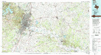
1985 Map of Austin
USGS Topo · Published 1992About this map
The Colorado River corridor defines the landscape of central Texas in the mid-1980s, anchoring a network of growing communities from Austin eastward to Bastrop. Significant military footprints are evident at Bergstrom Air Force Base and the expansive Camp Swift Military Reservation near McDade. This era shows the established urban grid of the state capital alongside outlying settlements like Round Rock, Pflugerville, and Elgin, many of which were still distinct from the main metropolitan center.
Find a feature on this map
86 named features on this map. Tap any name to fly to it.
Don’t see what you’re looking for? This feature index may not catch every label — zoom into the map to look around manually.
Map Details
Editions of this 1985 Austin Map
3 editions found
Other maps of this area

1885 · Taylor
USGS Topo · 1:125,000

1885 · Bastrop
USGS Topo · 1:125,000

1887 · Taylor
USGS Topo · 1:125,000

1887 · Blanco
USGS Topo · 1:125,000

1887 · Burnet
USGS Topo · 1:125,000

1893 · Georgetown
USGS Topo · 1:125,000

1893 · Burnet
USGS Topo · 1:125,000

1893 · Bastrop
USGS Topo · 1:125,000

1894 · Blanco
USGS Topo · 1:125,000

1894 · Taylor
USGS Topo · 1:125,000