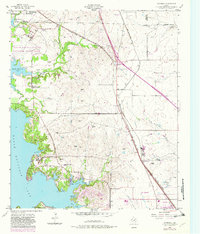
1955 Map of Avondale
USGS Topo · Published 1982About this map
The shoreline of Eagle Mountain Lake serves as a focal point for this survey of Northwest Tarrant County, which was updated in the early 1980s to reflect suburban expansion near Fort Worth. The landscape is a transition between the water's edge and the rail-oriented settlements of Avondale and Saginaw, showing a mix of established rural life and emerging infrastructure. Local community anchors are well-documented, including the Dido Ch and the Boy Scout Community Center near Gilmore.
Find a feature on this map
38 named features on this map. Tap any name to fly to it.
Don’t see what you’re looking for? This feature index may not catch every label — zoom into the map to look around manually.
Map Details
Editions of this 1955 Avondale Map
5 editions found
Other maps of this area

1891 · Weatherford
USGS Topo · 1:125,000

1893 · Weatherford
USGS Topo · 1:125,000

1894 · Fort Worth
USGS Topo · 1:125,000

1924 · Sunset 4-d
USGS Topo · 1:48,000

1930 · Boyd
USGS Topo · 1:62,500

1932 · Springtown
USGS Topo · 1:62,500

1954 · Dallas
USGS Topo · 1:250,000

1954 · Sherman
USGS Topo · 1:250,000

1955 · Haltom City
USGS Topo · 1:24,000

1955 · Avondale
USGS Topo · 1:24,000