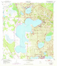
1952 Map of Babson Park
USGS Topo · Published 1973About this map
Crooked Lake dominates this central Florida landscape, its intricate shoreline defining the character of the Ridge section in Polk County. Surveyed by the U.S. Corps of Engineers in the early 1950s and updated with 1972 revisions, this map captures the citrus-growing region’s transition during a period of steady residential growth. The lakeside settlements of Babson Park, Hillcrest Heights, and Highland Park are shown in detail, including the 1970s urban extensions around Crooked Lake Park.
Find a feature on this map
21 named features on this map. Tap any name to fly to it.
Don’t see what you’re looking for? This feature index may not catch every label — zoom into the map to look around manually.
Map Details
Editions of this 1952 Babson Park Map
3 editions found
Other maps of this area

1952 · Lake Wales
USGS Topo · 1:24,000

1952 · Babson Park
USGS Topo · 1:24,000

1952 · Hesperides
USGS Topo · 1:24,000

1952 · Lake Arbuckle
USGS Topo · 1:24,000

1952 · Lake Weohyakapka
USGS Topo · 1:24,000

1953 · Frostproof
USGS Topo · 1:24,000

1955 · Eloise
USGS Topo · 1:24,000

1955 · Alturas
USGS Topo · 1:24,000

1956 · Bereah
USGS Topo · 1:24,000

1956 · Fort Pierce
USGS Topo · 1:250,000