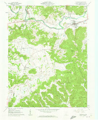
1961 Map of Bainbridge
USGS Topo · Published 1962About this map
Bainbridge sits at the northern edge of this 1961 survey, where the valley of Paint Creek meets the northern reaches of the Pike State Forest. The village is a central hub for the Detroit Toledo and Ironton railroad, which follows the creek valley past local landmarks like The Seven Caves and a Strip Mine located on the eastern ridge. To the south, the terrain becomes increasingly complex as it rises into the hills of the Virginia Military District, characterized by sharp ridges like Baker Ridge and Star Mountain. This landscape is dotted with small hilltop settlements and rural institutions, including Cynthiana and Lapperell, alongside scattered country churches such as Beech Flats Ch and Fairview Ch. The map also captures several family-named landmarks and cemeteries, including the Hulitt Cem and Jones Cem, providing a detailed look at the mid-century rural social geography of Ross, Pike, and Highland Counties.
Find a feature on this map
64 named features on this map. Tap any name to fly to it.
Don’t see what you’re looking for? This feature index may not catch every label — zoom into the map to look around manually.
Map Details
Editions of this 1961 Bainbridge Map
4 editions found
Other maps of this area

1912 · Roxabell
USGS Topo · 1:62,500

1914 · Roxabell
USGS Topo · 1:62,500

1915 · Bainbridge
USGS Topo · 1:48,000

1915 · Piketon
USGS Topo · 1:62,500

1917 · Bainbridge
USGS Topo · 1:62,500

1917 · Piketon
USGS Topo · 1:62,500

1917 · Greenfield
USGS Topo · 1:62,500

1944 · Piketon
USGS Topo · 1:62,500

1944 · Greenfield
USGS Topo · 1:62,500

1944 · Roxabell
USGS Topo · 1:62,500