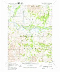
1955 Map of Baird Mountains D-3
USGS Topo · Published 1979About this map
The Noatak River carves through the centerpiece of this Arctic landscape, defining the dramatic corridor of the Grand Canyon within the Noatak Grand Canyon National Monument. Based on 1955 photogrammetric methods, the map captures a wilderness where drainage patterns dictate the terrain, from the northern Isacheluich Mountains down to the Angayukalik Hills. Significant tributaries like the Kaluktavik River and Mukachirak Creek feed into the main channel from the north and west, while the Nakolik River winds past the prominent Nakolik Mtn in the south. The absence of roads or permanent settlements highlights the region's character as an untouched natural preserve at the time of the survey, part of the newly established North Slope Borough boundary. It provides a technical record of a vast hydraulic network including Sisiak Creek and Nakolikurok Creek.
Find a feature on this map
12 named features on this map. Tap any name to fly to it.
Don’t see what you’re looking for? This feature index may not catch every label — zoom into the map to look around manually.
Map Details
Editions of this 1955 Baird Mountains D-3 Map
5 editions found
Other maps of this area

1951 · Baird Mountains
USGS Topo · 1:250,000

1951 · Misheguk Mountain
USGS Topo · 1:250,000

1955 · Baird Mountains D-4
USGS Topo · 1:63,360

1955 · Baird Mountains D-3
USGS Topo · 1:63,360

1955 · Misheguk Mountain A-3
USGS Topo · 1:63,360

1955 · Baird Mountains C-4
USGS Topo · 1:63,360

1955 · Baird Mountains C-3
USGS Topo · 1:63,360

1956 · Misheguk Mountain
USGS Topo · 1:250,000

1956 · Baird Mountains
USGS Topo · 1:250,000

1965 · Baird Mountains
USGS Topo · 1:250,000