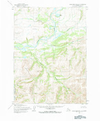
1955 Map of Baird Mountains D-3
USGS Topo · Published 1984About this map
The Noatak River cuts a wide, braided path through this Arctic landscape, serving as the central drainage for a network of named tributaries. Surveyed in the mid-1950s by the Army Map Service, the topography reveals a transition from the lower river valley into the prominent Angayukakik Hills. Evidence of early geodetic surveying is visible at Noatak East Base and Noatak West Base, baseline markers established for mapping this remote interior. North of the river, the Uyon Lakes and the winding Isaaktuvik Creek occupy a flatter basin before the terrain rises sharply into named peaks like Parka. The map documents a wilderness without established roads or trails, where drainage patterns like Kanayut Creek and Uluksiak Creek dictate the logic of the land.
Find a feature on this map
12 named features on this map. Tap any name to fly to it.
Don’t see what you’re looking for? This feature index may not catch every label — zoom into the map to look around manually.
Map Details
Editions of this 1955 Baird Mountains D-3 Map
5 editions found
Other maps of this area

1951 · Baird Mountains
USGS Topo · 1:250,000

1951 · Misheguk Mountain
USGS Topo · 1:250,000

1955 · Baird Mountains D-4
USGS Topo · 1:63,360

1955 · Baird Mountains D-3
USGS Topo · 1:63,360

1955 · Misheguk Mountain A-3
USGS Topo · 1:63,360

1955 · Baird Mountains C-4
USGS Topo · 1:63,360

1955 · Baird Mountains C-3
USGS Topo · 1:63,360

1956 · Misheguk Mountain
USGS Topo · 1:250,000

1956 · Baird Mountains
USGS Topo · 1:250,000

1965 · Baird Mountains
USGS Topo · 1:250,000