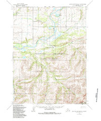
1955 Map of Baird Mountains D-3
USGS Topo · Published 1985About this map
The Noatak River dominates this Arctic landscape, carving a wide valley through the heart of what is now the Noatak National Preserve. This 1955 survey, later updated to reflect the boundaries established by the Alaska National Interest Lands Conservation Act, documents a wilderness devoid of roads or permanent settlements, where topographical surveying was conducted via aerial photogrammetry. The map identifies key landforms like Isaakluvik and geodetic markers such as Noatak East Base, which served as critical points for mapping this northern frontier.
Find a feature on this map
16 named features on this map. Tap any name to fly to it.
Don’t see what you’re looking for? This feature index may not catch every label — zoom into the map to look around manually.
Map Details
Editions of this 1955 Baird Mountains D-3 Map
5 editions found
Other maps of this area

1951 · Baird Mountains
USGS Topo · 1:250,000

1951 · Misheguk Mountain
USGS Topo · 1:250,000

1955 · Baird Mountains D-4
USGS Topo · 1:63,360

1955 · Baird Mountains D-3
USGS Topo · 1:63,360

1955 · Misheguk Mountain A-3
USGS Topo · 1:63,360

1955 · Baird Mountains C-4
USGS Topo · 1:63,360

1955 · Baird Mountains C-3
USGS Topo · 1:63,360

1956 · Misheguk Mountain
USGS Topo · 1:250,000

1956 · Baird Mountains
USGS Topo · 1:250,000

1965 · Baird Mountains
USGS Topo · 1:250,000