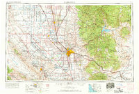
1962 Map of Bakersfield
USGS Topo · Published 1969About this map
Bakersfield sits at the heart of this mid-century landscape, a vital hub where the agricultural wealth of the Central Valley meets the industrial energy of surrounding oil fields. To the west, the Carrizo Plain and Temblor Range define a stark, arid geography, punctuated by the massive Naval Petroleum Reserve No 1. The eastern half of the map rises sharply into the Sierra Nevada and Greenhorn Mountains, where the Isabella Reservoir anchors the upper Kern River drainage within the Sequoia National Forest.
Find a feature on this map
75 named features on this map. Tap any name to fly to it.
Don’t see what you’re looking for? This feature index may not catch every label — zoom into the map to look around manually.
Map Details
Editions of this 1962 Bakersfield Map
4 editions found
Other maps of this area

1902 · Santa Ynez
USGS Topo · 1:125,000

1903 · Mt. Pinos
USGS Topo · 1:125,000

1903 · Tejon
USGS Topo · 1:125,000

1904 · Kaweah
USGS Topo · 1:125,000

1905 · Santa Ynez
USGS Topo · 1:125,000

1905 · Lompoc
USGS Topo · 1:125,000

1905 · Olancha
USGS Topo · 1:125,000

1905 · Fairview
USGS Topo · 1:24,000

1906 · Bakersfield
USGS Topo · 1:62,500

1906 · Kernville
USGS Topo · 1:125,000