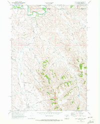
1968 Map of Bar N Draw
USGS Topo · Published 1972About this map
The Tongue River meanders across the border of Montana and Wyoming in this late 1960s survey, marking a landscape defined by an intricate network of drainage draws and irrigation. The terrain is deeply incised by family-named and descriptive features like Bar N Draw, Ash Draw, and Wheat Draw, illustrating the agricultural and ranching foundations of this region. Human intervention in the landscape is evident through the presence of water management features such as Ditch No 13 and an unnamed ditch following the path of Prairie Dog Creek.
Find a feature on this map
24 named features on this map. Tap any name to fly to it.
Don’t see what you’re looking for? This feature index may not catch every label — zoom into the map to look around manually.
Map Details
Editions of this 1968 Bar N Draw Map
2 editions found
Other maps of this area

1909 · Sheridan
USGS Topo · 1:125,000

1911 · Sheridan
USGS Topo · 1:125,000

1954 · Hardin
USGS Topo · 1:250,000

1955 · Sheridan
USGS Topo · 1:250,000

1957 · Hardin
USGS Topo · 1:250,000

1958 · Hardin
USGS Topo · 1:250,000

1958 · Sheridan
USGS Topo · 1:250,000

1962 · Sheridan
USGS Topo · 1:250,000

1967 · Holmes Ranch
USGS Topo · 1:24,000
1967 · Pearl School
USGS Topo · 1:24,000