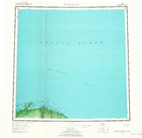
1959 Map of Barter Island
USGS Topo · Published 1965About this map
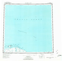
Barter Island and the coastal village of Kaktovik anchor this mid-century survey of Alaska's northernmost reaches along the Beaufort Sea. The landscape is defined by a complex network of barrier islands and lagoons, including Arey Island and Arey Lagoon, which protected the shoreline at the edge of the Arctic Ocean. Inland, the braided channels of the Jago River cut through the tundra, while a lone Tractor Trail provides the primary overland connection across the terrain. Human presence is marked by the Elupak (Site) and various coastal landmarks like Martin Pt and Griffin Pt. The map captures a pre-statehood era of exploration and remote habitation, indicated by labels for scattered Cabins, a Tower, and several triangulation stations such as VABM Barter. These features illustrate the navigational and strategic importance of this maritime boundary during the late 1950s.
Find a feature on this map
36 named features on this map. Tap any name to fly to it.
Don’t see what you’re looking for? This feature index may not catch every label — zoom into the map to look around manually.
Map Details
Editions of this 1959 Barter Island Map
7 editions found

Other maps of this area

1951 · Barter Island
USGS Topo · 1:250,000

1951 · Demarcation Point
USGS Topo · 1:250,000

1951 · Mt. Michelson
USGS Topo · 1:250,000

1955 · Flaxman Island
USGS Topo · 1:250,000

1955 · Demarcation Point
USGS Topo · 1:250,000

1955 · Flaxman Island A-1
USGS Topo · 1:63,360

1955 · Demarcation Point D-3
USGS Topo · 1:63,360

1955 · Barter Island A-5
USGS Topo · 1:63,360

1955 · Demarcation Point D-2
USGS Topo · 1:63,360

1955 · Barter Island A-4
USGS Topo · 1:63,360